You are here: Home > Network List > TA - USArray Transportable Network (new EarthScope stations) Stations List
> Station G21K Allakaket, AK, USA > Earthquake Result Viewer
G21K Allakaket, AK, USA - Earthquake Result Viewer
| Earthquake location: |
New Guinea, Papua New Guinea |
| Earthquake latitude/longitude: |
-6.3/142.6 |
| Earthquake time(UTC): |
2018/03/06 (065) 14:13:06 GMT |
| Earthquake Depth: |
10 km |
| Earthquake Magnitude: |
6.7 Mww |
| Earthquake Catalog/Contributor: |
NEIC PDE/us |
|
| Network: |
TA USArray Transportable Network (new EarthScope stations) |
| Station: |
G21K Allakaket, AK, USA |
| Lat/Lon: |
66.52 N/153.51 W |
| Elevation: |
446 m |
|
| Distance: |
85.7 deg |
| Az: |
21.154 deg |
| Baz: |
243.527 deg |
| Ray Param: |
0.044601552 |
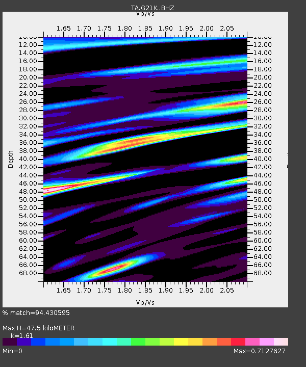
| Estimated Moho Depth: |
47.5 km |
| Estimated Crust Vp/Vs: |
1.61 |
| Assumed Crust Vp: |
6.455 km/s |
| Estimated Crust Vs: |
4.009 km/s |
| Estimated Crust Poisson's Ratio: |
0.19 |
|
| Radial Match: |
94.430595 % |
| Radial Bump: |
400 |
| Transverse Match: |
84.30914 % |
| Transverse Bump: |
400 |
| SOD ConfigId: |
13570011 |
| Insert Time: |
2019-04-29 22:12:15.709 +0000 |
| GWidth: |
2.5 |
| Max Bumps: |
400 |
| Tol: |
0.001 |
|

Signal To Noise
| Channel | StoN | STA | LTA |
| TA:G21K: :BHZ:20180306T14:25:13.324993Z | 6.318888 | 7.1805994E-7 | 1.1363707E-7 |
| TA:G21K: :BHN:20180306T14:25:13.324993Z | 1.2530255 | 1.348905E-7 | 1.0765184E-7 |
| TA:G21K: :BHE:20180306T14:25:13.324993Z | 1.734015 | 1.7398072E-7 | 1.0033404E-7 |
| Arrivals |
| Ps | 4.6 SECOND |
| PpPs | 19 SECOND |
| PsPs/PpSs | 23 SECOND |


