You are here: Home > Network List > TA - USArray Transportable Network (new EarthScope stations) Stations List
> Station G31M Satah River, YT, CAN > Earthquake Result Viewer
G31M Satah River, YT, CAN - Earthquake Result Viewer
| Earthquake location: |
New Guinea, Papua New Guinea |
| Earthquake latitude/longitude: |
-6.3/142.6 |
| Earthquake time(UTC): |
2018/03/06 (065) 14:13:06 GMT |
| Earthquake Depth: |
10 km |
| Earthquake Magnitude: |
6.7 Mww |
| Earthquake Catalog/Contributor: |
NEIC PDE/us |
|
| Network: |
TA USArray Transportable Network (new EarthScope stations) |
| Station: |
G31M Satah River, YT, CAN |
| Lat/Lon: |
66.92 N/134.27 W |
| Elevation: |
61 m |
|
| Distance: |
93.0 deg |
| Az: |
23.074 deg |
| Baz: |
261.225 deg |
| Ray Param: |
0.04133829 |
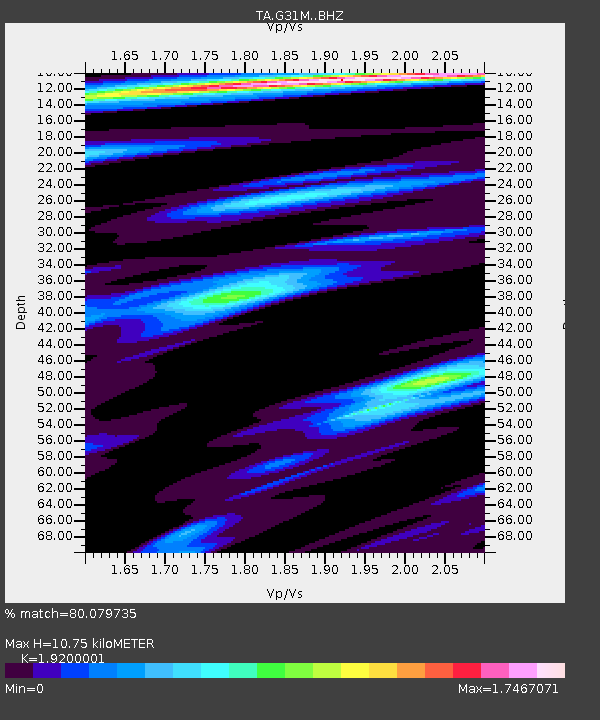
| Estimated Moho Depth: |
10.75 km |
| Estimated Crust Vp/Vs: |
1.92 |
| Assumed Crust Vp: |
6.171 km/s |
| Estimated Crust Vs: |
3.214 km/s |
| Estimated Crust Poisson's Ratio: |
0.31 |
|
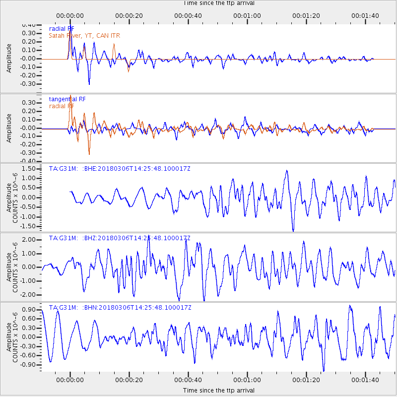
| Radial Match: |
80.079735 % |
| Radial Bump: |
313 |
| Transverse Match: |
49.690376 % |
| Transverse Bump: |
364 |
| SOD ConfigId: |
13570011 |
| Insert Time: |
2019-04-29 22:12:21.824 +0000 |
| GWidth: |
2.5 |
| Max Bumps: |
400 |
| Tol: |
0.001 |
|
Signal To Noise
| Channel | StoN | STA | LTA |
| TA:G31M: :BHZ:20180306T14:25:48.100017Z | 3.8891597 | 6.6860486E-7 | 1.7191499E-7 |
| TA:G31M: :BHN:20180306T14:25:48.100017Z | 0.8970824 | 3.4136664E-7 | 3.8052988E-7 |
| TA:G31M: :BHE:20180306T14:25:48.100017Z | 1.0435185 | 2.574753E-7 | 2.467376E-7 |
| Arrivals |
| Ps | 1.6 SECOND |
| PpPs | 5.0 SECOND |
| PsPs/PpSs | 6.6 SECOND |


