You are here: Home > Network List > TA - USArray Transportable Network (new EarthScope stations) Stations List
> Station I28M Miner Creek, YT, CAN > Earthquake Result Viewer
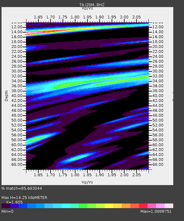
I28M Miner Creek, YT, CAN - Earthquake Result Viewer
| Earthquake location: |
New Guinea, Papua New Guinea |
| Earthquake latitude/longitude: |
-6.3/142.6 |
| Earthquake time(UTC): |
2018/03/06 (065) 14:13:06 GMT |
| Earthquake Depth: |
10 km |
| Earthquake Magnitude: |
6.7 Mww |
| Earthquake Catalog/Contributor: |
NEIC PDE/us |
|
| Network: |
TA USArray Transportable Network (new EarthScope stations) |
| Station: |
I28M Miner Creek, YT, CAN |
| Lat/Lon: |
65.45 N/139.94 W |
| Elevation: |
1188 m |
|
| Distance: |
90.5 deg |
| Az: |
24.071 deg |
| Baz: |
256.016 deg |
| Ray Param: |
0.04166898 |
| Estimated Moho Depth: |
14.25 km |
| Estimated Crust Vp/Vs: |
1.61 |
| Assumed Crust Vp: |
6.566 km/s |
| Estimated Crust Vs: |
4.091 km/s |
| Estimated Crust Poisson's Ratio: |
0.18 |
|
| Radial Match: |
85.683044 % |
| Radial Bump: |
400 |
| Transverse Match: |
66.0506 % |
| Transverse Bump: |
400 |
| SOD ConfigId: |
13570011 |
| Insert Time: |
2019-04-29 22:12:36.943 +0000 |
| GWidth: |
2.5 |
| Max Bumps: |
400 |
| Tol: |
0.001 |
|

Signal To Noise
| Channel | StoN | STA | LTA |
| TA:I28M: :BHZ:20180306T14:25:36.350017Z | 2.8909628 | 4.836285E-7 | 1.6728978E-7 |
| TA:I28M: :BHN:20180306T14:25:36.350017Z | 0.82713985 | 1.9408449E-7 | 2.3464531E-7 |
| TA:I28M: :BHE:20180306T14:25:36.350017Z | 1.3949449 | 2.2840356E-7 | 1.6373662E-7 |
| Arrivals |
| Ps | 1.3 SECOND |
| PpPs | 5.5 SECOND |
| PsPs/PpSs | 6.9 SECOND |


