You are here: Home > Network List > TA - USArray Transportable Network (new EarthScope stations) Stations List
> Station I30M Mount Dempster, Yukon, CAN > Earthquake Result Viewer
I30M Mount Dempster, Yukon, CAN - Earthquake Result Viewer
| Earthquake location: |
New Guinea, Papua New Guinea |
| Earthquake latitude/longitude: |
-6.3/142.6 |
| Earthquake time(UTC): |
2018/03/06 (065) 14:13:06 GMT |
| Earthquake Depth: |
10 km |
| Earthquake Magnitude: |
6.7 Mww |
| Earthquake Catalog/Contributor: |
NEIC PDE/us |
|
| Network: |
TA USArray Transportable Network (new EarthScope stations) |
| Station: |
I30M Mount Dempster, Yukon, CAN |
| Lat/Lon: |
65.22 N/136.38 W |
| Elevation: |
1399 m |
|
| Distance: |
91.9 deg |
| Az: |
24.613 deg |
| Baz: |
259.236 deg |
| Ray Param: |
0.041538283 |
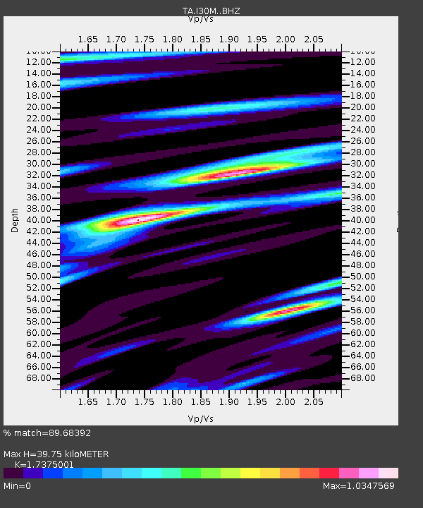
| Estimated Moho Depth: |
39.75 km |
| Estimated Crust Vp/Vs: |
1.74 |
| Assumed Crust Vp: |
6.566 km/s |
| Estimated Crust Vs: |
3.779 km/s |
| Estimated Crust Poisson's Ratio: |
0.25 |
|
| Radial Match: |
89.68392 % |
| Radial Bump: |
323 |
| Transverse Match: |
81.03701 % |
| Transverse Bump: |
400 |
| SOD ConfigId: |
13570011 |
| Insert Time: |
2019-04-29 22:12:37.950 +0000 |
| GWidth: |
2.5 |
| Max Bumps: |
400 |
| Tol: |
0.001 |
|
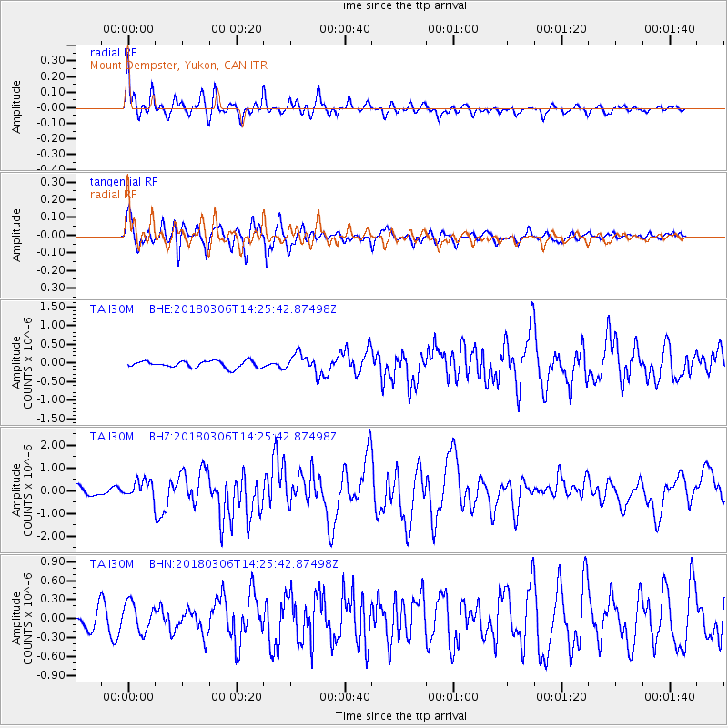
Signal To Noise
| Channel | StoN | STA | LTA |
| TA:I30M: :BHZ:20180306T14:25:42.87498Z | 2.0968096 | 3.8977913E-7 | 1.8589152E-7 |
| TA:I30M: :BHN:20180306T14:25:42.87498Z | 1.8845154 | 2.3542319E-7 | 1.2492505E-7 |
| TA:I30M: :BHE:20180306T14:25:42.87498Z | 2.4909937 | 2.2489597E-7 | 9.0283635E-8 |
| Arrivals |
| Ps | 4.6 SECOND |
| PpPs | 16 SECOND |
| PsPs/PpSs | 21 SECOND |


