You are here: Home > Network List > TA - USArray Transportable Network (new EarthScope stations) Stations List
> Station C09A Chrisman Ranch, Davenport, WA, USA > Earthquake Result Viewer
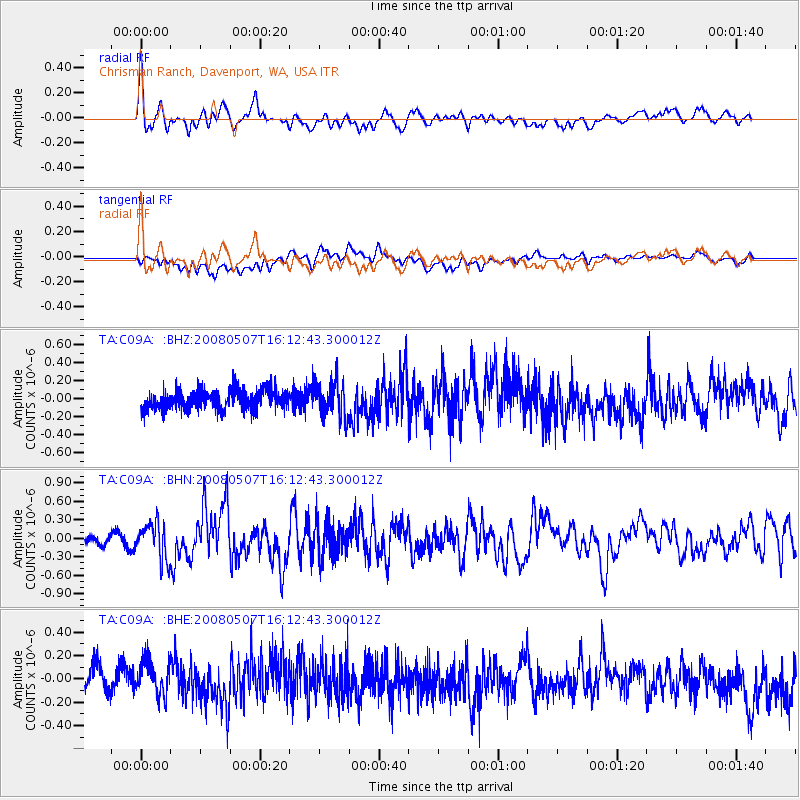
C09A Chrisman Ranch, Davenport, WA, USA - Earthquake Result Viewer
*The percent match for this event was below the threshold and hence no stack was calculated.
| Earthquake location: |
Near East Coast Of Honshu, Japan |
| Earthquake latitude/longitude: |
36.2/141.5 |
| Earthquake time(UTC): |
2008/05/07 (128) 16:02:02 GMT |
| Earthquake Depth: |
19 km |
| Earthquake Magnitude: |
5.7 MB, 6.2 MW, 6.2 MW |
| Earthquake Catalog/Contributor: |
WHDF/NEIC |
|
| Network: |
TA USArray Transportable Network (new EarthScope stations) |
| Station: |
C09A Chrisman Ranch, Davenport, WA, USA |
| Lat/Lon: |
47.80 N/118.27 W |
| Elevation: |
495 m |
|
| Distance: |
70.3 deg |
| Az: |
44.827 deg |
| Baz: |
302.219 deg |
| Ray Param: |
$rayparam |
*The percent match for this event was below the threshold and hence was not used in the summary stack. |
|
| Radial Match: |
78.805885 % |
| Radial Bump: |
400 |
| Transverse Match: |
45.193275 % |
| Transverse Bump: |
400 |
| SOD ConfigId: |
2504 |
| Insert Time: |
2010-03-06 09:37:48.552 +0000 |
| GWidth: |
2.5 |
| Max Bumps: |
400 |
| Tol: |
0.001 |
|
Signal To Noise
| Channel | StoN | STA | LTA |
| TA:C09A: :BHN:20080507T16:12:43.300012Z | 3.1855927 | 2.9436336E-7 | 9.240459E-8 |
| TA:C09A: :BHE:20080507T16:12:43.300012Z | 1.5019544 | 1.605658E-7 | 1.0690458E-7 |
| TA:C09A: :BHZ:20080507T16:12:43.300012Z | 1.8489916 | 1.9705288E-7 | 1.0657316E-7 |
| Arrivals |
| Ps | |
| PpPs | |
| PsPs/PpSs | |


