You are here: Home > Network List > TA - USArray Transportable Network (new EarthScope stations) Stations List
> Station N17K Nushagak Hills, AK, USA > Earthquake Result Viewer
N17K Nushagak Hills, AK, USA - Earthquake Result Viewer
| Earthquake location: |
New Guinea, Papua New Guinea |
| Earthquake latitude/longitude: |
-6.3/142.6 |
| Earthquake time(UTC): |
2018/03/06 (065) 14:13:06 GMT |
| Earthquake Depth: |
10 km |
| Earthquake Magnitude: |
6.7 Mww |
| Earthquake Catalog/Contributor: |
NEIC PDE/us |
|
| Network: |
TA USArray Transportable Network (new EarthScope stations) |
| Station: |
N17K Nushagak Hills, AK, USA |
| Lat/Lon: |
60.53 N/157.19 W |
| Elevation: |
350 m |
|
| Distance: |
81.4 deg |
| Az: |
25.724 deg |
| Baz: |
240.747 deg |
| Ray Param: |
0.04761703 |
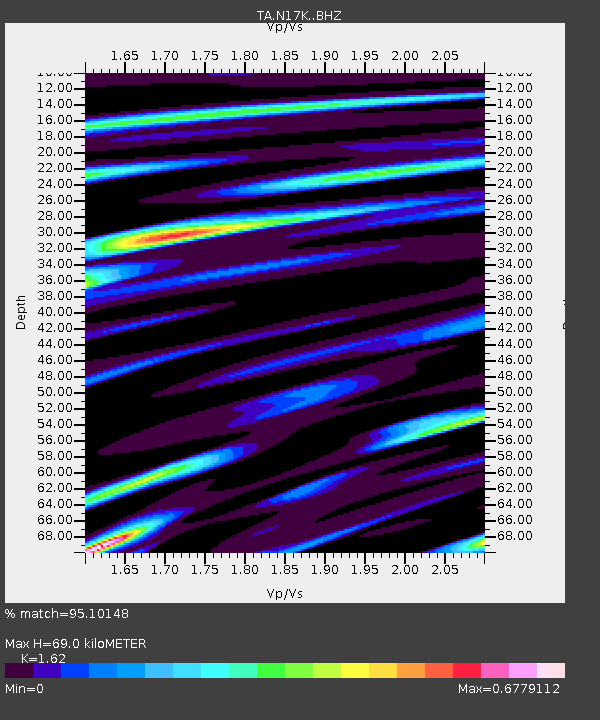
| Estimated Moho Depth: |
69.0 km |
| Estimated Crust Vp/Vs: |
1.62 |
| Assumed Crust Vp: |
6.155 km/s |
| Estimated Crust Vs: |
3.799 km/s |
| Estimated Crust Poisson's Ratio: |
0.19 |
|
| Radial Match: |
95.10148 % |
| Radial Bump: |
400 |
| Transverse Match: |
84.71779 % |
| Transverse Bump: |
400 |
| SOD ConfigId: |
13570011 |
| Insert Time: |
2019-04-29 22:13:13.572 +0000 |
| GWidth: |
2.5 |
| Max Bumps: |
400 |
| Tol: |
0.001 |
|

Signal To Noise
| Channel | StoN | STA | LTA |
| TA:N17K: :BHZ:20180306T14:24:51.475017Z | 4.7764225 | 8.2115884E-7 | 1.7191921E-7 |
| TA:N17K: :BHN:20180306T14:24:51.475017Z | 2.2030284 | 2.625139E-7 | 1.1916048E-7 |
| TA:N17K: :BHE:20180306T14:24:51.475017Z | 2.6645157 | 2.5054166E-7 | 9.402897E-8 |
| Arrivals |
| Ps | 7.1 SECOND |
| PpPs | 29 SECOND |
| PsPs/PpSs | 36 SECOND |


