You are here: Home > Network List > TA - USArray Transportable Network (new EarthScope stations) Stations List
> Station P17K Kvichak River, AK, USA > Earthquake Result Viewer
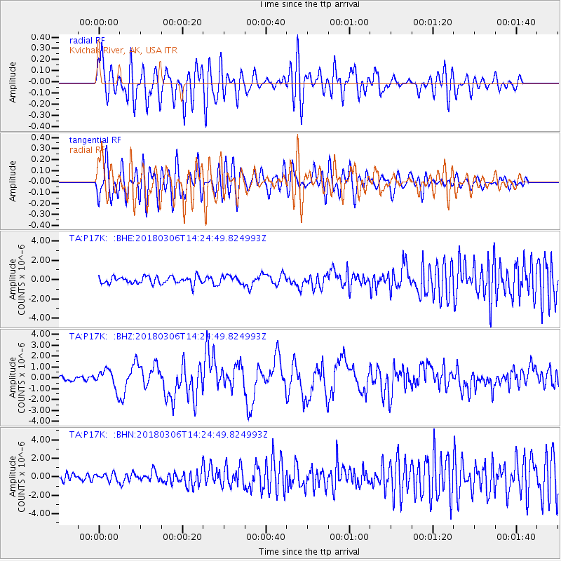
P17K Kvichak River, AK, USA - Earthquake Result Viewer
*The percent match for this event was below the threshold and hence no stack was calculated.
| Earthquake location: |
New Guinea, Papua New Guinea |
| Earthquake latitude/longitude: |
-6.3/142.6 |
| Earthquake time(UTC): |
2018/03/06 (065) 14:13:06 GMT |
| Earthquake Depth: |
10 km |
| Earthquake Magnitude: |
6.7 Mww |
| Earthquake Catalog/Contributor: |
NEIC PDE/us |
|
| Network: |
TA USArray Transportable Network (new EarthScope stations) |
| Station: |
P17K Kvichak River, AK, USA |
| Lat/Lon: |
59.20 N/156.44 W |
| Elevation: |
91 m |
|
| Distance: |
81.1 deg |
| Az: |
27.092 deg |
| Baz: |
241.601 deg |
| Ray Param: |
$rayparam |
*The percent match for this event was below the threshold and hence was not used in the summary stack. |
|
| Radial Match: |
77.05118 % |
| Radial Bump: |
400 |
| Transverse Match: |
71.05235 % |
| Transverse Bump: |
400 |
| SOD ConfigId: |
13570011 |
| Insert Time: |
2019-04-29 22:13:25.646 +0000 |
| GWidth: |
2.5 |
| Max Bumps: |
400 |
| Tol: |
0.001 |
|
Signal To Noise
| Channel | StoN | STA | LTA |
| TA:P17K: :BHZ:20180306T14:24:49.824993Z | 4.3625975 | 9.2051044E-7 | 2.1100054E-7 |
| TA:P17K: :BHN:20180306T14:24:49.824993Z | 0.90389353 | 3.8998115E-7 | 4.314459E-7 |
| TA:P17K: :BHE:20180306T14:24:49.824993Z | 1.0802003 | 4.0817392E-7 | 3.7786873E-7 |
| Arrivals |
| Ps | |
| PpPs | |
| PsPs/PpSs | |


