You are here: Home > Network List > TA - USArray Transportable Network (new EarthScope stations) Stations List
> Station P29M Windy Craggy, BC, CAN > Earthquake Result Viewer
P29M Windy Craggy, BC, CAN - Earthquake Result Viewer

| Earthquake location: |
New Guinea, Papua New Guinea |
| Earthquake latitude/longitude: |
-6.3/142.6 |
| Earthquake time(UTC): |
2018/03/06 (065) 14:13:06 GMT |
| Earthquake Depth: |
10 km |
| Earthquake Magnitude: |
6.7 Mww |
| Earthquake Catalog/Contributor: |
NEIC PDE/us |
|
| Network: |
TA USArray Transportable Network (new EarthScope stations) |
| Station: |
P29M Windy Craggy, BC, CAN |
| Lat/Lon: |
59.63 N/137.74 W |
| Elevation: |
679 m |
|
| Distance: |
90.2 deg |
| Az: |
29.99 deg |
| Baz: |
257.931 deg |
| Ray Param: |
0.041692063 |
| Estimated Moho Depth: |
23.0 km |
| Estimated Crust Vp/Vs: |
1.60 |
| Assumed Crust Vp: |
6.566 km/s |
| Estimated Crust Vs: |
4.104 km/s |
| Estimated Crust Poisson's Ratio: |
0.18 |
|
| Radial Match: |
83.36694 % |
| Radial Bump: |
400 |
| Transverse Match: |
81.72567 % |
| Transverse Bump: |
400 |
| SOD ConfigId: |
13570011 |
| Insert Time: |
2019-04-29 22:13:30.551 +0000 |
| GWidth: |
2.5 |
| Max Bumps: |
400 |
| Tol: |
0.001 |
|
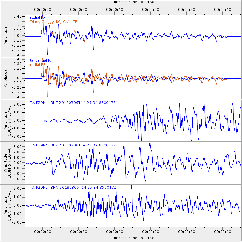
Signal To Noise
| Channel | StoN | STA | LTA |
| TA:P29M: :BHZ:20180306T14:25:34.850017Z | 1.8431951 | 5.404172E-7 | 2.9319588E-7 |
| TA:P29M: :BHN:20180306T14:25:34.850017Z | 0.9368669 | 1.2537701E-7 | 1.3382586E-7 |
| TA:P29M: :BHE:20180306T14:25:34.850017Z | 2.1202326 | 2.7661054E-7 | 1.3046235E-7 |
| Arrivals |
| Ps | 2.2 SECOND |
| PpPs | 8.9 SECOND |
| PsPs/PpSs | 11 SECOND |


