You are here: Home > Network List > UW - Pacific Northwest Regional Seismic Network Stations List
> Station LEBA Lebam, WA, USA > Earthquake Result Viewer
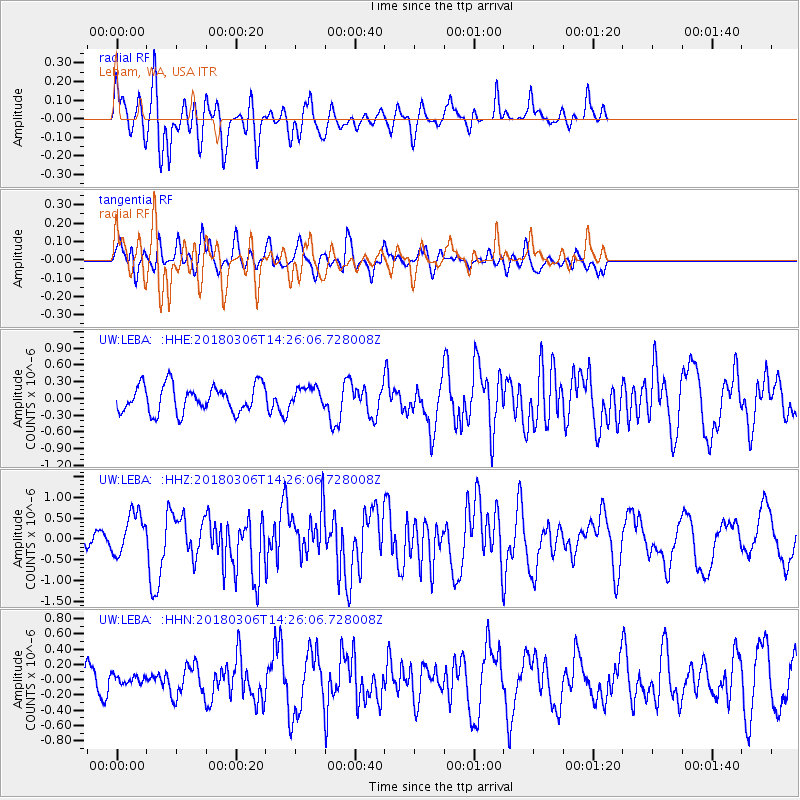
LEBA Lebam, WA, USA - Earthquake Result Viewer
*The percent match for this event was below the threshold and hence no stack was calculated.
| Earthquake location: |
New Guinea, Papua New Guinea |
| Earthquake latitude/longitude: |
-6.3/142.6 |
| Earthquake time(UTC): |
2018/03/06 (065) 14:13:06 GMT |
| Earthquake Depth: |
10 km |
| Earthquake Magnitude: |
6.7 Mww |
| Earthquake Catalog/Contributor: |
NEIC PDE/us |
|
| Network: |
UW Pacific Northwest Regional Seismic Network |
| Station: |
LEBA Lebam, WA, USA |
| Lat/Lon: |
46.55 N/123.56 W |
| Elevation: |
73 m |
|
| Distance: |
97.2 deg |
| Az: |
43.953 deg |
| Baz: |
268.434 deg |
| Ray Param: |
$rayparam |
*The percent match for this event was below the threshold and hence was not used in the summary stack. |
|
| Radial Match: |
75.06808 % |
| Radial Bump: |
400 |
| Transverse Match: |
63.855465 % |
| Transverse Bump: |
400 |
| SOD ConfigId: |
13570011 |
| Insert Time: |
2019-04-29 22:13:58.102 +0000 |
| GWidth: |
2.5 |
| Max Bumps: |
400 |
| Tol: |
0.001 |
|
Signal To Noise
| Channel | StoN | STA | LTA |
| UW:LEBA: :HHZ:20180306T14:26:06.728008Z | 3.2604687 | 5.070092E-7 | 1.5550194E-7 |
| UW:LEBA: :HHN:20180306T14:26:06.728008Z | 0.26743278 | 6.279221E-8 | 2.3479625E-7 |
| UW:LEBA: :HHE:20180306T14:26:06.728008Z | 0.7268811 | 1.7697373E-7 | 2.4347E-7 |
| Arrivals |
| Ps | |
| PpPs | |
| PsPs/PpSs | |


