You are here: Home > Network List > CI - Caltech Regional Seismic Network Stations List
> Station MPM Manuel Prospect Mine, California, USA > Earthquake Result Viewer
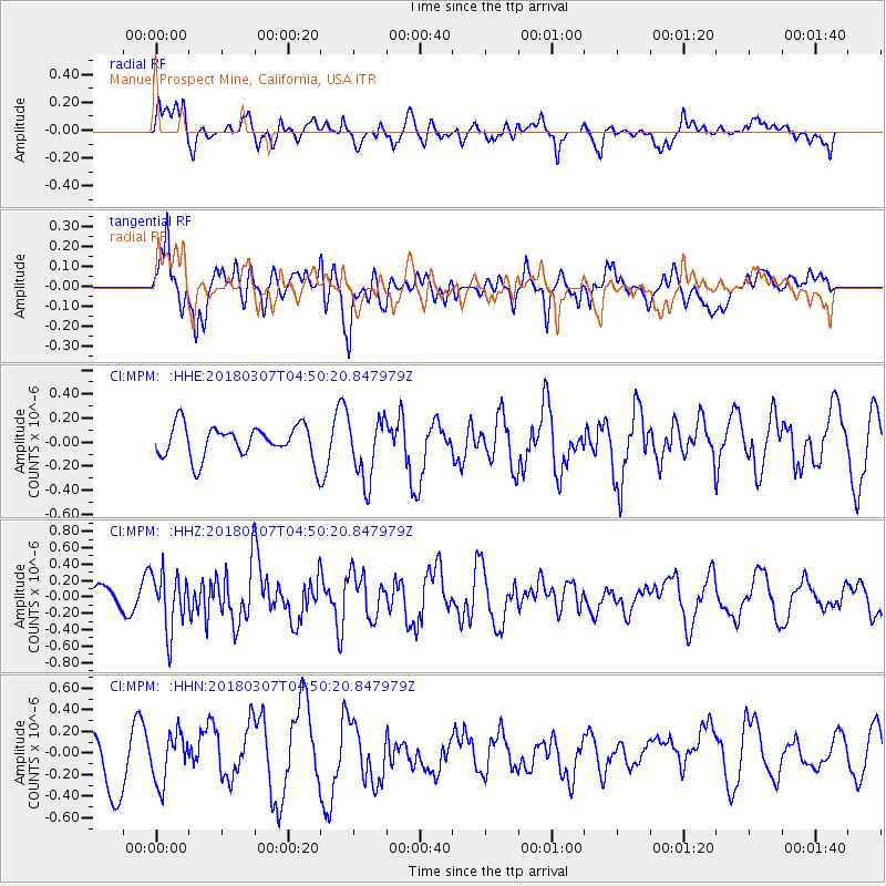
MPM Manuel Prospect Mine, California, USA - Earthquake Result Viewer
*The percent match for this event was below the threshold and hence no stack was calculated.
| Earthquake location: |
East Of Kuril Islands |
| Earthquake latitude/longitude: |
45.8/152.3 |
| Earthquake time(UTC): |
2018/03/07 (066) 04:40:12 GMT |
| Earthquake Depth: |
29 km |
| Earthquake Magnitude: |
5.8 Mww |
| Earthquake Catalog/Contributor: |
NEIC PDE/us |
|
| Network: |
CI Caltech Regional Seismic Network |
| Station: |
MPM Manuel Prospect Mine, California, USA |
| Lat/Lon: |
36.06 N/117.49 W |
| Elevation: |
185 m |
|
| Distance: |
65.4 deg |
| Az: |
63.048 deg |
| Baz: |
309.715 deg |
| Ray Param: |
$rayparam |
*The percent match for this event was below the threshold and hence was not used in the summary stack. |
|
| Radial Match: |
50.06754 % |
| Radial Bump: |
400 |
| Transverse Match: |
46.521545 % |
| Transverse Bump: |
400 |
| SOD ConfigId: |
13570011 |
| Insert Time: |
2019-04-29 22:17:29.645 +0000 |
| GWidth: |
2.5 |
| Max Bumps: |
400 |
| Tol: |
0.001 |
|
Signal To Noise
| Channel | StoN | STA | LTA |
| CI:MPM: :HHZ:20180307T04:50:20.847979Z | 2.90773 | 3.476058E-7 | 1.1954542E-7 |
| CI:MPM: :HHN:20180307T04:50:20.847979Z | 0.9087833 | 2.403018E-7 | 2.6442146E-7 |
| CI:MPM: :HHE:20180307T04:50:20.847979Z | 1.9041171 | 2.6094068E-7 | 1.3704026E-7 |
| Arrivals |
| Ps | |
| PpPs | |
| PsPs/PpSs | |


