You are here: Home > Network List > CN - Canadian National Seismograph Network Stations List
> Station INK INUVIK, NT > Earthquake Result Viewer
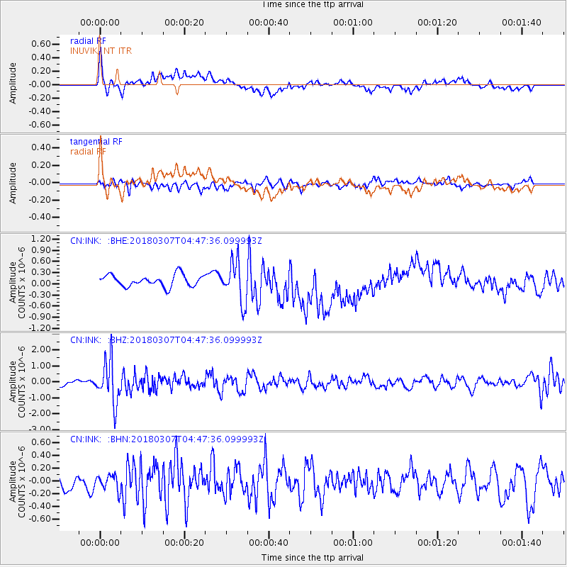
INK INUVIK, NT - Earthquake Result Viewer
*The percent match for this event was below the threshold and hence no stack was calculated.
| Earthquake location: |
East Of Kuril Islands |
| Earthquake latitude/longitude: |
45.8/152.3 |
| Earthquake time(UTC): |
2018/03/07 (066) 04:40:12 GMT |
| Earthquake Depth: |
29 km |
| Earthquake Magnitude: |
5.8 Mww |
| Earthquake Catalog/Contributor: |
NEIC PDE/us |
|
| Network: |
CN Canadian National Seismograph Network |
| Station: |
INK INUVIK, NT |
| Lat/Lon: |
68.31 N/133.53 W |
| Elevation: |
44 m |
|
| Distance: |
42.7 deg |
| Az: |
31.811 deg |
| Baz: |
277.525 deg |
| Ray Param: |
$rayparam |
*The percent match for this event was below the threshold and hence was not used in the summary stack. |
|
| Radial Match: |
45.02961 % |
| Radial Bump: |
400 |
| Transverse Match: |
54.96003 % |
| Transverse Bump: |
400 |
| SOD ConfigId: |
13570011 |
| Insert Time: |
2019-04-29 22:18:10.561 +0000 |
| GWidth: |
2.5 |
| Max Bumps: |
400 |
| Tol: |
0.001 |
|
Signal To Noise
| Channel | StoN | STA | LTA |
| CN:INK: :BHZ:20180307T04:47:36.099993Z | 7.3961954 | 1.3497613E-6 | 1.82494E-7 |
| CN:INK: :BHN:20180307T04:47:36.099993Z | 0.9037085 | 1.2305144E-7 | 1.3616275E-7 |
| CN:INK: :BHE:20180307T04:47:36.099993Z | 3.6127195 | 5.6232767E-7 | 1.5565219E-7 |
| Arrivals |
| Ps | |
| PpPs | |
| PsPs/PpSs | |


