You are here: Home > Network List > TA - USArray Transportable Network (new EarthScope stations) Stations List
> Station B15A Bradely Ranch, Valier, MT, USA > Earthquake Result Viewer
B15A Bradely Ranch, Valier, MT, USA - Earthquake Result Viewer
| Earthquake location: |
Andreanof Islands, Aleutian Is. |
| Earthquake latitude/longitude: |
51.4/-179.5 |
| Earthquake time(UTC): |
2007/12/19 (353) 09:30:27 GMT |
| Earthquake Depth: |
29 km |
| Earthquake Magnitude: |
6.4 MB, 7.1 MS, 7.1 MW, 7.0 MW |
| Earthquake Catalog/Contributor: |
WHDF/NEIC |
|
| Network: |
TA USArray Transportable Network (new EarthScope stations) |
| Station: |
B15A Bradely Ranch, Valier, MT, USA |
| Lat/Lon: |
48.31 N/112.56 W |
| Elevation: |
1222 m |
|
| Distance: |
41.9 deg |
| Az: |
66.802 deg |
| Baz: |
300.318 deg |
| Ray Param: |
0.073416695 |
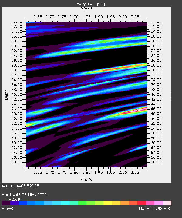
| Estimated Moho Depth: |
46.25 km |
| Estimated Crust Vp/Vs: |
2.06 |
| Assumed Crust Vp: |
6.178 km/s |
| Estimated Crust Vs: |
2.999 km/s |
| Estimated Crust Poisson's Ratio: |
0.35 |
|
| Radial Match: |
86.52135 % |
| Radial Bump: |
400 |
| Transverse Match: |
82.44388 % |
| Transverse Bump: |
370 |
| SOD ConfigId: |
2564 |
| Insert Time: |
2010-03-06 09:40:04.585 +0000 |
| GWidth: |
2.5 |
| Max Bumps: |
400 |
| Tol: |
0.001 |
|

Signal To Noise
| Channel | StoN | STA | LTA |
| TA:B15A: :BHN:20071219T09:37:44.700002Z | 2.1149502 | 1.4384864E-6 | 6.8015146E-7 |
| TA:B15A: :BHE:20071219T09:37:44.700002Z | 3.6903586 | 1.8783959E-6 | 5.0900087E-7 |
| TA:B15A: :BHZ:20071219T09:37:44.700002Z | 7.501878 | 4.825358E-6 | 6.4322E-7 |
| Arrivals |
| Ps | 8.4 SECOND |
| PpPs | 22 SECOND |
| PsPs/PpSs | 30 SECOND |


