You are here: Home > Network List > TA - USArray Transportable Network (new EarthScope stations) Stations List
> Station B15A Bradely Ranch, Valier, MT, USA > Earthquake Result Viewer
B15A Bradely Ranch, Valier, MT, USA - Earthquake Result Viewer
| Earthquake location: |
Kuril Islands |
| Earthquake latitude/longitude: |
46.0/151.5 |
| Earthquake time(UTC): |
2009/04/07 (097) 04:23:33 GMT |
| Earthquake Depth: |
31 km |
| Earthquake Magnitude: |
6.5 MB, 6.8 MS, 6.9 MW, 6.9 MW |
| Earthquake Catalog/Contributor: |
WHDF/NEIC |
|
| Network: |
TA USArray Transportable Network (new EarthScope stations) |
| Station: |
B15A Bradely Ranch, Valier, MT, USA |
| Lat/Lon: |
48.31 N/112.56 W |
| Elevation: |
1222 m |
|
| Distance: |
60.9 deg |
| Az: |
49.471 deg |
| Baz: |
307.534 deg |
| Ray Param: |
0.06118668 |
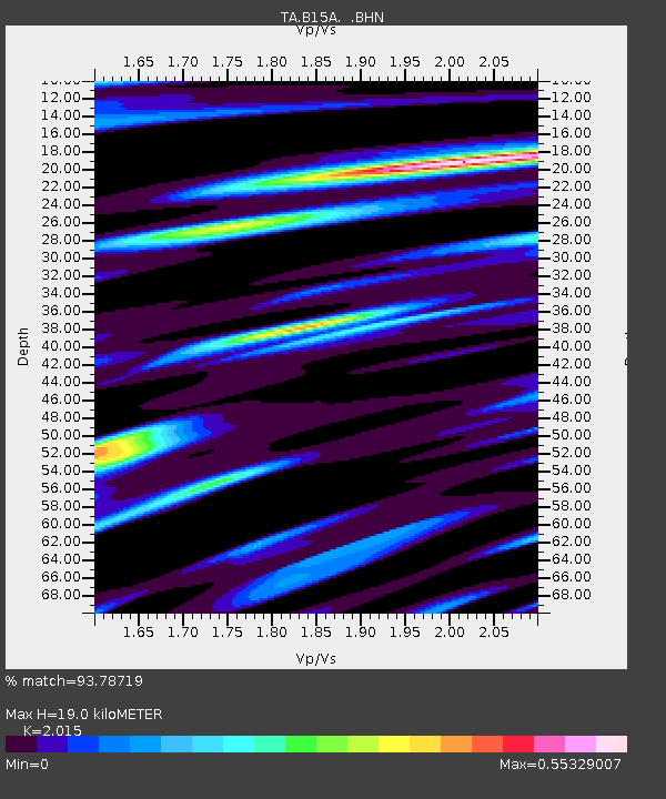
| Estimated Moho Depth: |
19.0 km |
| Estimated Crust Vp/Vs: |
2.02 |
| Assumed Crust Vp: |
6.178 km/s |
| Estimated Crust Vs: |
3.066 km/s |
| Estimated Crust Poisson's Ratio: |
0.34 |
|
| Radial Match: |
93.78719 % |
| Radial Bump: |
400 |
| Transverse Match: |
78.988884 % |
| Transverse Bump: |
400 |
| SOD ConfigId: |
2658 |
| Insert Time: |
2010-03-06 09:40:28.997 +0000 |
| GWidth: |
2.5 |
| Max Bumps: |
400 |
| Tol: |
0.001 |
|

Signal To Noise
| Channel | StoN | STA | LTA |
| TA:B15A: :BHN:20090407T04:33:11.949011Z | 22.279642 | 5.749068E-6 | 2.580413E-7 |
| TA:B15A: :BHE:20090407T04:33:11.949011Z | 6.690427 | 1.5109281E-6 | 2.2583434E-7 |
| TA:B15A: :BHZ:20090407T04:33:11.949011Z | 11.340074 | 2.039529E-6 | 1.7985147E-7 |
| Arrivals |
| Ps | 3.2 SECOND |
| PpPs | 8.9 SECOND |
| PsPs/PpSs | 12 SECOND |


