You are here: Home > Network List > TA - USArray Transportable Network (new EarthScope stations) Stations List
> Station 121A Cookes Peak, Deming, NM, USA > Earthquake Result Viewer
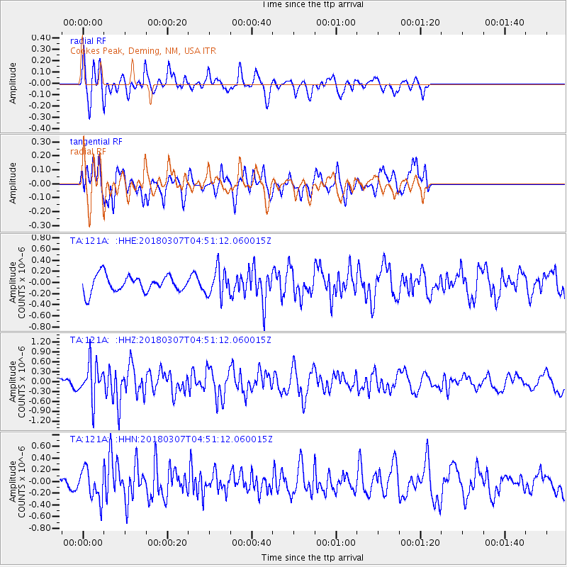
121A Cookes Peak, Deming, NM, USA - Earthquake Result Viewer
*The percent match for this event was below the threshold and hence no stack was calculated.
| Earthquake location: |
East Of Kuril Islands |
| Earthquake latitude/longitude: |
45.8/152.3 |
| Earthquake time(UTC): |
2018/03/07 (066) 04:40:12 GMT |
| Earthquake Depth: |
29 km |
| Earthquake Magnitude: |
5.8 Mww |
| Earthquake Catalog/Contributor: |
NEIC PDE/us |
|
| Network: |
TA USArray Transportable Network (new EarthScope stations) |
| Station: |
121A Cookes Peak, Deming, NM, USA |
| Lat/Lon: |
32.53 N/107.79 W |
| Elevation: |
1652 m |
|
| Distance: |
73.7 deg |
| Az: |
60.107 deg |
| Baz: |
314.138 deg |
| Ray Param: |
$rayparam |
*The percent match for this event was below the threshold and hence was not used in the summary stack. |
|
| Radial Match: |
52.272594 % |
| Radial Bump: |
400 |
| Transverse Match: |
57.30696 % |
| Transverse Bump: |
400 |
| SOD ConfigId: |
13570011 |
| Insert Time: |
2019-04-29 22:23:37.335 +0000 |
| GWidth: |
2.5 |
| Max Bumps: |
400 |
| Tol: |
0.001 |
|
Signal To Noise
| Channel | StoN | STA | LTA |
| TA:121A: :HHZ:20180307T04:51:12.060015Z | 3.6778412 | 5.533714E-7 | 1.5046093E-7 |
| TA:121A: :HHN:20180307T04:51:12.060015Z | 1.4119141 | 2.6387895E-7 | 1.868945E-7 |
| TA:121A: :HHE:20180307T04:51:12.060015Z | 1.6576817 | 2.4534734E-7 | 1.480063E-7 |
| Arrivals |
| Ps | |
| PpPs | |
| PsPs/PpSs | |


