You are here: Home > Network List > TA - USArray Transportable Network (new EarthScope stations) Stations List
> Station B18K Kokolik River, AK, USA > Earthquake Result Viewer
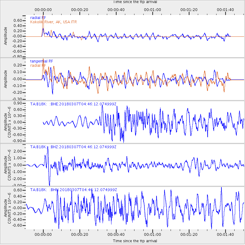
B18K Kokolik River, AK, USA - Earthquake Result Viewer
*The percent match for this event was below the threshold and hence no stack was calculated.
| Earthquake location: |
East Of Kuril Islands |
| Earthquake latitude/longitude: |
45.8/152.3 |
| Earthquake time(UTC): |
2018/03/07 (066) 04:40:12 GMT |
| Earthquake Depth: |
29 km |
| Earthquake Magnitude: |
5.8 Mww |
| Earthquake Catalog/Contributor: |
NEIC PDE/us |
|
| Network: |
TA USArray Transportable Network (new EarthScope stations) |
| Station: |
B18K Kokolik River, AK, USA |
| Lat/Lon: |
69.36 N/161.80 W |
| Elevation: |
222 m |
|
| Distance: |
32.8 deg |
| Az: |
28.068 deg |
| Baz: |
248.137 deg |
| Ray Param: |
$rayparam |
*The percent match for this event was below the threshold and hence was not used in the summary stack. |
|
| Radial Match: |
67.34469 % |
| Radial Bump: |
400 |
| Transverse Match: |
59.070164 % |
| Transverse Bump: |
400 |
| SOD ConfigId: |
13570011 |
| Insert Time: |
2019-04-29 22:23:38.427 +0000 |
| GWidth: |
2.5 |
| Max Bumps: |
400 |
| Tol: |
0.001 |
|
Signal To Noise
| Channel | StoN | STA | LTA |
| TA:B18K: :BHZ:20180307T04:46:12.074999Z | 8.692992 | 1.3014742E-6 | 1.4971532E-7 |
| TA:B18K: :BHN:20180307T04:46:12.074999Z | 1.0641122 | 1.5529838E-7 | 1.4594174E-7 |
| TA:B18K: :BHE:20180307T04:46:12.074999Z | 2.2708752 | 3.1707145E-7 | 1.3962521E-7 |
| Arrivals |
| Ps | |
| PpPs | |
| PsPs/PpSs | |


