You are here: Home > Network List > TA - USArray Transportable Network (new EarthScope stations) Stations List
> Station B15A Bradely Ranch, Valier, MT, USA > Earthquake Result Viewer
B15A Bradely Ranch, Valier, MT, USA - Earthquake Result Viewer
| Earthquake location: |
Near Coast Of Guatemala |
| Earthquake latitude/longitude: |
13.6/-90.6 |
| Earthquake time(UTC): |
2008/04/15 (106) 03:03:04 GMT |
| Earthquake Depth: |
33 km |
| Earthquake Magnitude: |
5.6 MB, 5.8 MS, 6.1 MW, 6.1 MW |
| Earthquake Catalog/Contributor: |
WHDF/NEIC |
|
| Network: |
TA USArray Transportable Network (new EarthScope stations) |
| Station: |
B15A Bradely Ranch, Valier, MT, USA |
| Lat/Lon: |
48.31 N/112.56 W |
| Elevation: |
1222 m |
|
| Distance: |
39.1 deg |
| Az: |
336.702 deg |
| Baz: |
144.819 deg |
| Ray Param: |
0.07509141 |
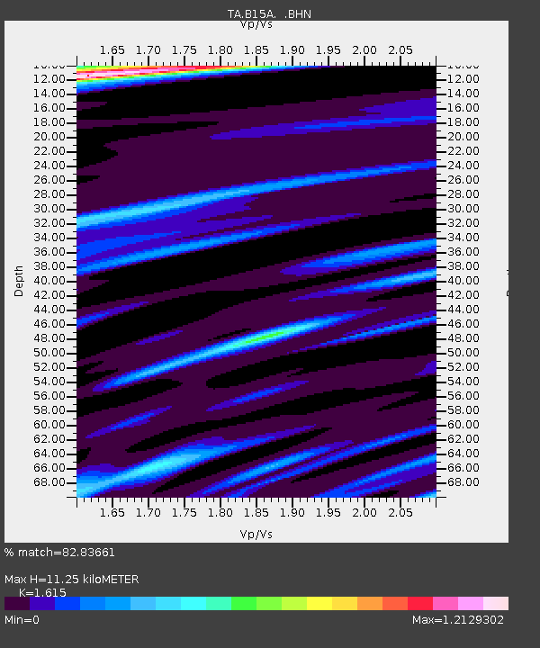
| Estimated Moho Depth: |
11.25 km |
| Estimated Crust Vp/Vs: |
1.62 |
| Assumed Crust Vp: |
6.178 km/s |
| Estimated Crust Vs: |
3.826 km/s |
| Estimated Crust Poisson's Ratio: |
0.19 |
|
| Radial Match: |
82.83661 % |
| Radial Bump: |
336 |
| Transverse Match: |
45.65366 % |
| Transverse Bump: |
385 |
| SOD ConfigId: |
2504 |
| Insert Time: |
2010-03-06 09:40:37.660 +0000 |
| GWidth: |
2.5 |
| Max Bumps: |
400 |
| Tol: |
0.001 |
|

Signal To Noise
| Channel | StoN | STA | LTA |
| TA:B15A: :BHN:20080415T03:09:58.700009Z | 3.7229393 | 6.8537946E-7 | 1.8409634E-7 |
| TA:B15A: :BHE:20080415T03:09:58.700009Z | 1.6939751 | 3.1569752E-7 | 1.8636491E-7 |
| TA:B15A: :BHZ:20080415T03:09:58.700009Z | 2.7661176 | 4.152083E-7 | 1.5010508E-7 |
| Arrivals |
| Ps | 1.2 SECOND |
| PpPs | 4.4 SECOND |
| PsPs/PpSs | 5.6 SECOND |


