You are here: Home > Network List > TA - USArray Transportable Network (new EarthScope stations) Stations List
> Station D23K Nanushuk River, AK USA > Earthquake Result Viewer
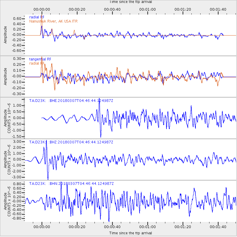
D23K Nanushuk River, AK USA - Earthquake Result Viewer
*The percent match for this event was below the threshold and hence no stack was calculated.
| Earthquake location: |
East Of Kuril Islands |
| Earthquake latitude/longitude: |
45.8/152.3 |
| Earthquake time(UTC): |
2018/03/07 (066) 04:40:12 GMT |
| Earthquake Depth: |
29 km |
| Earthquake Magnitude: |
5.8 Mww |
| Earthquake Catalog/Contributor: |
NEIC PDE/us |
|
| Network: |
TA USArray Transportable Network (new EarthScope stations) |
| Station: |
D23K Nanushuk River, AK USA |
| Lat/Lon: |
68.97 N/150.68 W |
| Elevation: |
406 m |
|
| Distance: |
36.5 deg |
| Az: |
30.626 deg |
| Baz: |
260.632 deg |
| Ray Param: |
$rayparam |
*The percent match for this event was below the threshold and hence was not used in the summary stack. |
|
| Radial Match: |
72.71024 % |
| Radial Bump: |
400 |
| Transverse Match: |
56.128773 % |
| Transverse Bump: |
400 |
| SOD ConfigId: |
13570011 |
| Insert Time: |
2019-04-29 22:23:51.886 +0000 |
| GWidth: |
2.5 |
| Max Bumps: |
400 |
| Tol: |
0.001 |
|
Signal To Noise
| Channel | StoN | STA | LTA |
| TA:D23K: :BHZ:20180307T04:46:44.124987Z | 7.5632787 | 1.5006464E-6 | 1.9841215E-7 |
| TA:D23K: :BHN:20180307T04:46:44.124987Z | 1.0702738 | 1.910806E-7 | 1.7853434E-7 |
| TA:D23K: :BHE:20180307T04:46:44.124987Z | 4.5029383 | 6.5492026E-7 | 1.4544287E-7 |
| Arrivals |
| Ps | |
| PpPs | |
| PsPs/PpSs | |


