You are here: Home > Network List > TA - USArray Transportable Network (new EarthScope stations) Stations List
> Station G31M Satah River, YT, CAN > Earthquake Result Viewer
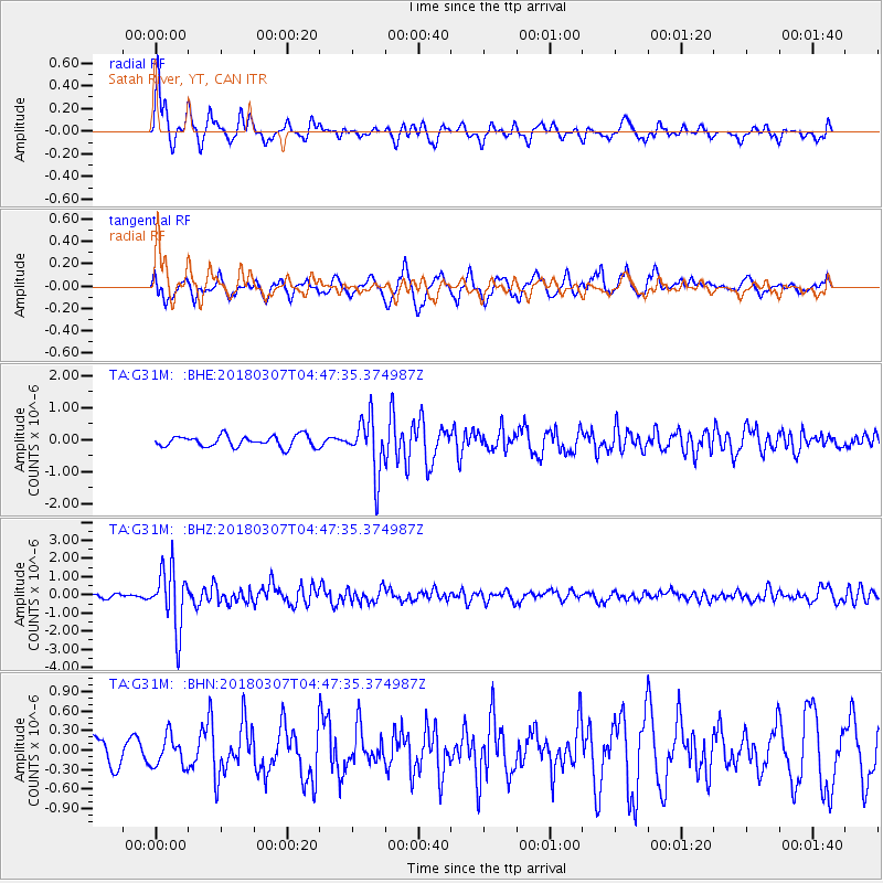
G31M Satah River, YT, CAN - Earthquake Result Viewer
*The percent match for this event was below the threshold and hence no stack was calculated.
| Earthquake location: |
East Of Kuril Islands |
| Earthquake latitude/longitude: |
45.8/152.3 |
| Earthquake time(UTC): |
2018/03/07 (066) 04:40:12 GMT |
| Earthquake Depth: |
29 km |
| Earthquake Magnitude: |
5.8 Mww |
| Earthquake Catalog/Contributor: |
NEIC PDE/us |
|
| Network: |
TA USArray Transportable Network (new EarthScope stations) |
| Station: |
G31M Satah River, YT, CAN |
| Lat/Lon: |
66.92 N/134.27 W |
| Elevation: |
61 m |
|
| Distance: |
42.6 deg |
| Az: |
33.9 deg |
| Baz: |
278.372 deg |
| Ray Param: |
$rayparam |
*The percent match for this event was below the threshold and hence was not used in the summary stack. |
|
| Radial Match: |
75.63028 % |
| Radial Bump: |
380 |
| Transverse Match: |
49.958733 % |
| Transverse Bump: |
383 |
| SOD ConfigId: |
13570011 |
| Insert Time: |
2019-04-29 22:24:18.775 +0000 |
| GWidth: |
2.5 |
| Max Bumps: |
400 |
| Tol: |
0.001 |
|
Signal To Noise
| Channel | StoN | STA | LTA |
| TA:G31M: :BHZ:20180307T04:47:35.374987Z | 7.5175204 | 1.6415067E-6 | 2.1835747E-7 |
| TA:G31M: :BHN:20180307T04:47:35.374987Z | 0.71956104 | 2.3204035E-7 | 3.2247488E-7 |
| TA:G31M: :BHE:20180307T04:47:35.374987Z | 4.846325 | 8.573605E-7 | 1.7690941E-7 |
| Arrivals |
| Ps | |
| PpPs | |
| PsPs/PpSs | |


