You are here: Home > Network List > TA - USArray Transportable Network (new EarthScope stations) Stations List
> Station B15A Bradely Ranch, Valier, MT, USA > Earthquake Result Viewer
B15A Bradely Ranch, Valier, MT, USA - Earthquake Result Viewer
| Earthquake location: |
Iceland |
| Earthquake latitude/longitude: |
64.0/-21.0 |
| Earthquake time(UTC): |
2008/05/29 (150) 15:46:00 GMT |
| Earthquake Depth: |
10 km |
| Earthquake Magnitude: |
6.0 MB, 6.2 MS, 6.3 MW, 6.2 MW |
| Earthquake Catalog/Contributor: |
WHDF/NEIC |
|
| Network: |
TA USArray Transportable Network (new EarthScope stations) |
| Station: |
B15A Bradely Ranch, Valier, MT, USA |
| Lat/Lon: |
48.31 N/112.56 W |
| Elevation: |
1222 m |
|
| Distance: |
48.7 deg |
| Az: |
297.294 deg |
| Baz: |
35.921 deg |
| Ray Param: |
0.06920779 |
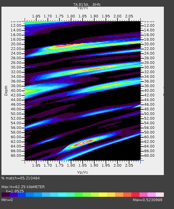
| Estimated Moho Depth: |
62.25 km |
| Estimated Crust Vp/Vs: |
1.85 |
| Assumed Crust Vp: |
6.178 km/s |
| Estimated Crust Vs: |
3.335 km/s |
| Estimated Crust Poisson's Ratio: |
0.29 |
|
| Radial Match: |
85.210464 % |
| Radial Bump: |
366 |
| Transverse Match: |
64.93158 % |
| Transverse Bump: |
389 |
| SOD ConfigId: |
2504 |
| Insert Time: |
2010-03-06 09:40:53.222 +0000 |
| GWidth: |
2.5 |
| Max Bumps: |
400 |
| Tol: |
0.001 |
|

Signal To Noise
| Channel | StoN | STA | LTA |
| TA:B15A: :BHN:20080529T15:54:13.700011Z | 10.730942 | 7.529732E-7 | 7.016842E-8 |
| TA:B15A: :BHE:20080529T15:54:13.700011Z | 1.9283776 | 2.59511E-7 | 1.3457478E-7 |
| TA:B15A: :BHZ:20080529T15:54:13.700011Z | 2.2100372 | 1.9627741E-7 | 8.881181E-8 |
| Arrivals |
| Ps | 9.1 SECOND |
| PpPs | 27 SECOND |
| PsPs/PpSs | 36 SECOND |


