You are here: Home > Network List > TA - USArray Transportable Network (new EarthScope stations) Stations List
> Station B15A Bradely Ranch, Valier, MT, USA > Earthquake Result Viewer
B15A Bradely Ranch, Valier, MT, USA - Earthquake Result Viewer
| Earthquake location: |
Tonga Islands |
| Earthquake latitude/longitude: |
-20.8/-173.3 |
| Earthquake time(UTC): |
2008/06/26 (178) 21:19:15 GMT |
| Earthquake Depth: |
38 km |
| Earthquake Magnitude: |
6.0 MB, 5.8 MS, 6.2 MW, 6.1 MW |
| Earthquake Catalog/Contributor: |
WHDF/NEIC |
|
| Network: |
TA USArray Transportable Network (new EarthScope stations) |
| Station: |
B15A Bradely Ranch, Valier, MT, USA |
| Lat/Lon: |
48.31 N/112.56 W |
| Elevation: |
1222 m |
|
| Distance: |
87.6 deg |
| Az: |
35.671 deg |
| Baz: |
234.832 deg |
| Ray Param: |
0.0431813 |
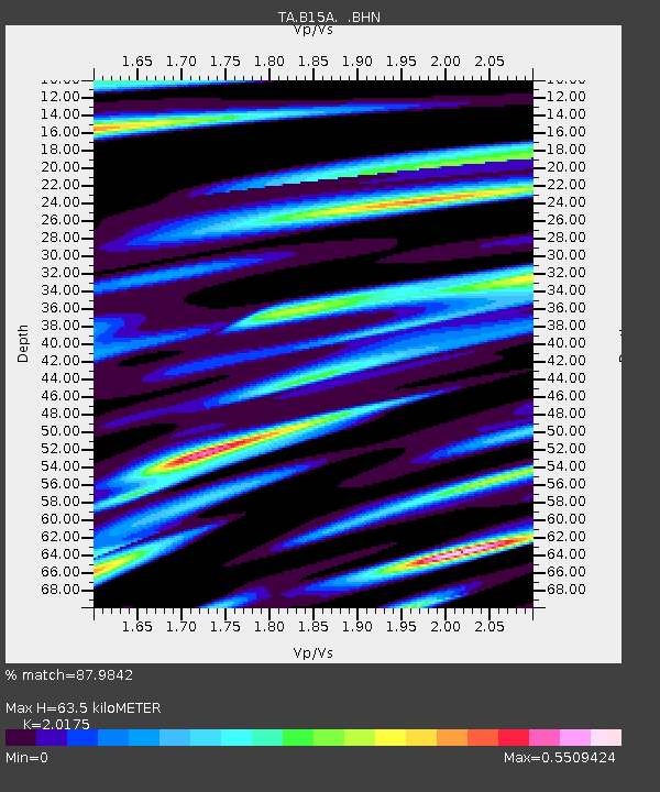
| Estimated Moho Depth: |
63.5 km |
| Estimated Crust Vp/Vs: |
2.02 |
| Assumed Crust Vp: |
6.178 km/s |
| Estimated Crust Vs: |
3.062 km/s |
| Estimated Crust Poisson's Ratio: |
0.34 |
|
| Radial Match: |
87.9842 % |
| Radial Bump: |
400 |
| Transverse Match: |
79.510635 % |
| Transverse Bump: |
392 |
| SOD ConfigId: |
2504 |
| Insert Time: |
2010-03-06 09:41:02.810 +0000 |
| GWidth: |
2.5 |
| Max Bumps: |
400 |
| Tol: |
0.001 |
|

Signal To Noise
| Channel | StoN | STA | LTA |
| TA:B15A: :BHN:20080626T21:31:28.423994Z | 17.138657 | 1.5581729E-6 | 9.09157E-8 |
| TA:B15A: :BHE:20080626T21:31:28.423994Z | 2.7207701 | 3.7158028E-7 | 1.3657173E-7 |
| TA:B15A: :BHZ:20080626T21:31:28.423994Z | 6.3625245 | 4.172079E-7 | 6.55727E-8 |
| Arrivals |
| Ps | 11 SECOND |
| PpPs | 30 SECOND |
| PsPs/PpSs | 41 SECOND |


