You are here: Home > Network List > US - United States National Seismic Network Stations List
> Station LKWY Lake (Yellowstone--Lake), Wyoming, USA > Earthquake Result Viewer
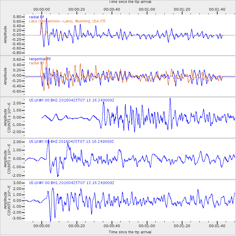
LKWY Lake (Yellowstone--Lake), Wyoming, USA - Earthquake Result Viewer
*The percent match for this event was below the threshold and hence no stack was calculated.
| Earthquake location: |
Near Coast Of Chiapas, Mexico |
| Earthquake latitude/longitude: |
14.4/-93.1 |
| Earthquake time(UTC): |
2016/04/25 (116) 07:07:09 GMT |
| Earthquake Depth: |
26 km |
| Earthquake Magnitude: |
5.6 MB |
| Earthquake Catalog/Contributor: |
NEIC PDE/NEIC COMCAT |
|
| Network: |
US United States National Seismic Network |
| Station: |
LKWY Lake (Yellowstone--Lake), Wyoming, USA |
| Lat/Lon: |
44.57 N/110.40 W |
| Elevation: |
2424 m |
|
| Distance: |
33.5 deg |
| Az: |
337.333 deg |
| Baz: |
148.508 deg |
| Ray Param: |
$rayparam |
*The percent match for this event was below the threshold and hence was not used in the summary stack. |
|
| Radial Match: |
59.545483 % |
| Radial Bump: |
400 |
| Transverse Match: |
67.223976 % |
| Transverse Bump: |
400 |
| SOD ConfigId: |
1475611 |
| Insert Time: |
2016-05-09 07:13:16.244 +0000 |
| GWidth: |
2.5 |
| Max Bumps: |
400 |
| Tol: |
0.001 |
|
Signal To Noise
| Channel | StoN | STA | LTA |
| US:LKWY:00:BHZ:20160425T07:13:16.249009Z | 3.8500166 | 8.884044E-7 | 2.307534E-7 |
| US:LKWY:00:BH1:20160425T07:13:16.249009Z | 9.630063 | 8.219992E-7 | 8.535761E-8 |
| US:LKWY:00:BH2:20160425T07:13:16.249009Z | 3.0937479 | 5.9670094E-7 | 1.9287316E-7 |
| Arrivals |
| Ps | |
| PpPs | |
| PsPs/PpSs | |


