You are here: Home > Network List > TA - USArray Transportable Network (new EarthScope stations) Stations List
> Station M31M Drury Creek, Yukon, CA > Earthquake Result Viewer
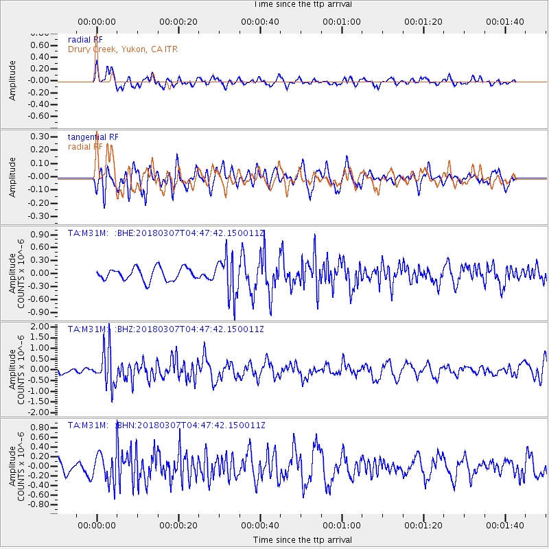
M31M Drury Creek, Yukon, CA - Earthquake Result Viewer
*The percent match for this event was below the threshold and hence no stack was calculated.
| Earthquake location: |
East Of Kuril Islands |
| Earthquake latitude/longitude: |
45.8/152.3 |
| Earthquake time(UTC): |
2018/03/07 (066) 04:40:12 GMT |
| Earthquake Depth: |
29 km |
| Earthquake Magnitude: |
5.8 Mww |
| Earthquake Catalog/Contributor: |
NEIC PDE/us |
|
| Network: |
TA USArray Transportable Network (new EarthScope stations) |
| Station: |
M31M Drury Creek, Yukon, CA |
| Lat/Lon: |
62.20 N/134.39 W |
| Elevation: |
639 m |
|
| Distance: |
43.5 deg |
| Az: |
40.735 deg |
| Baz: |
283.26 deg |
| Ray Param: |
$rayparam |
*The percent match for this event was below the threshold and hence was not used in the summary stack. |
|
| Radial Match: |
57.578968 % |
| Radial Bump: |
400 |
| Transverse Match: |
61.72322 % |
| Transverse Bump: |
400 |
| SOD ConfigId: |
13570011 |
| Insert Time: |
2019-04-29 22:25:05.515 +0000 |
| GWidth: |
2.5 |
| Max Bumps: |
400 |
| Tol: |
0.001 |
|
Signal To Noise
| Channel | StoN | STA | LTA |
| TA:M31M: :BHZ:20180307T04:47:42.150011Z | 5.880624 | 8.502418E-7 | 1.4458361E-7 |
| TA:M31M: :BHN:20180307T04:47:42.150011Z | 1.5625714 | 3.0538737E-7 | 1.9543897E-7 |
| TA:M31M: :BHE:20180307T04:47:42.150011Z | 3.2058136 | 4.6165823E-7 | 1.4400656E-7 |
| Arrivals |
| Ps | |
| PpPs | |
| PsPs/PpSs | |


