You are here: Home > Network List > TA - USArray Transportable Network (new EarthScope stations) Stations List
> Station V35K Ketchikan, AK, USA > Earthquake Result Viewer
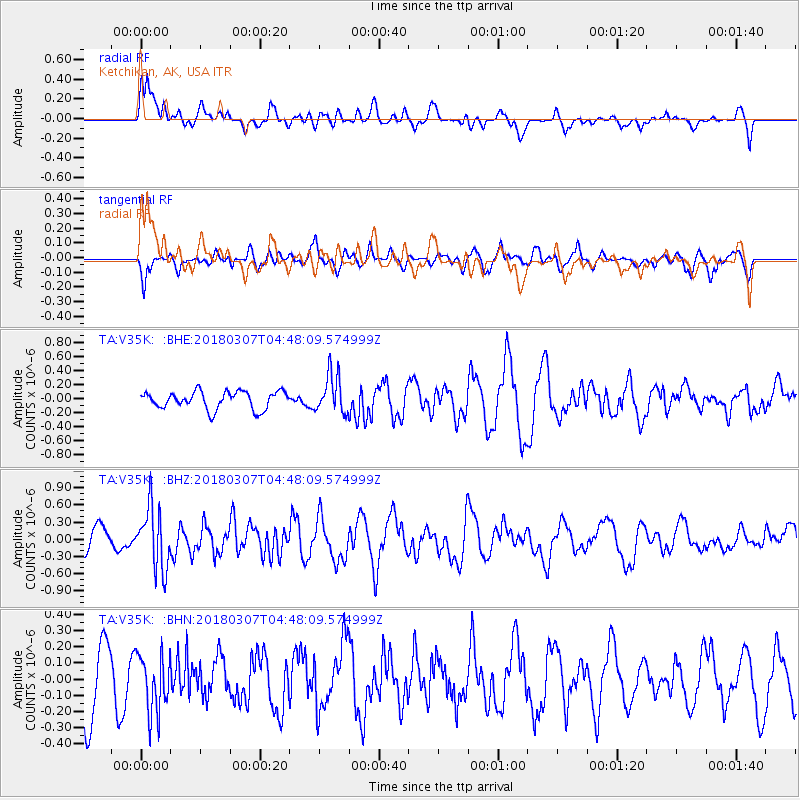
V35K Ketchikan, AK, USA - Earthquake Result Viewer
*The percent match for this event was below the threshold and hence no stack was calculated.
| Earthquake location: |
East Of Kuril Islands |
| Earthquake latitude/longitude: |
45.8/152.3 |
| Earthquake time(UTC): |
2018/03/07 (066) 04:40:12 GMT |
| Earthquake Depth: |
29 km |
| Earthquake Magnitude: |
5.8 Mww |
| Earthquake Catalog/Contributor: |
NEIC PDE/us |
|
| Network: |
TA USArray Transportable Network (new EarthScope stations) |
| Station: |
V35K Ketchikan, AK, USA |
| Lat/Lon: |
55.33 N/131.62 W |
| Elevation: |
64 m |
|
| Distance: |
46.9 deg |
| Az: |
49.388 deg |
| Baz: |
291.738 deg |
| Ray Param: |
$rayparam |
*The percent match for this event was below the threshold and hence was not used in the summary stack. |
|
| Radial Match: |
59.968098 % |
| Radial Bump: |
400 |
| Transverse Match: |
45.53085 % |
| Transverse Bump: |
400 |
| SOD ConfigId: |
13570011 |
| Insert Time: |
2019-04-29 22:25:44.834 +0000 |
| GWidth: |
2.5 |
| Max Bumps: |
400 |
| Tol: |
0.001 |
|
Signal To Noise
| Channel | StoN | STA | LTA |
| TA:V35K: :BHZ:20180307T04:48:09.574999Z | 2.8866386 | 5.3076707E-7 | 1.8387028E-7 |
| TA:V35K: :BHN:20180307T04:48:09.574999Z | 0.6988516 | 1.8246216E-7 | 2.6108856E-7 |
| TA:V35K: :BHE:20180307T04:48:09.574999Z | 2.1334894 | 2.6800723E-7 | 1.256192E-7 |
| Arrivals |
| Ps | |
| PpPs | |
| PsPs/PpSs | |


