You are here: Home > Network List > WY - Yellowstone Wyoming Seismic Network Stations List
> Station YHH Holmes Hill, YNP, WY, USA > Earthquake Result Viewer
YHH Holmes Hill, YNP, WY, USA - Earthquake Result Viewer
*The percent match for this event was below the threshold and hence no stack was calculated.
| Earthquake location: |
Near Coast Of Chiapas, Mexico |
| Earthquake latitude/longitude: |
14.4/-93.1 |
| Earthquake time(UTC): |
2016/04/25 (116) 07:07:09 GMT |
| Earthquake Depth: |
26 km |
| Earthquake Magnitude: |
5.6 MB |
| Earthquake Catalog/Contributor: |
NEIC PDE/NEIC COMCAT |
|
| Network: |
WY Yellowstone Wyoming Seismic Network |
| Station: |
YHH Holmes Hill, YNP, WY, USA |
| Lat/Lon: |
44.79 N/110.85 W |
| Elevation: |
2717 m |
|
| Distance: |
33.8 deg |
| Az: |
337.052 deg |
| Baz: |
147.958 deg |
| Ray Param: |
$rayparam |
*The percent match for this event was below the threshold and hence was not used in the summary stack. |
|
| Radial Match: |
77.87895 % |
| Radial Bump: |
400 |
| Transverse Match: |
65.63341 % |
| Transverse Bump: |
400 |
| SOD ConfigId: |
1475611 |
| Insert Time: |
2016-05-09 07:15:17.548 +0000 |
| GWidth: |
2.5 |
| Max Bumps: |
400 |
| Tol: |
0.001 |
|
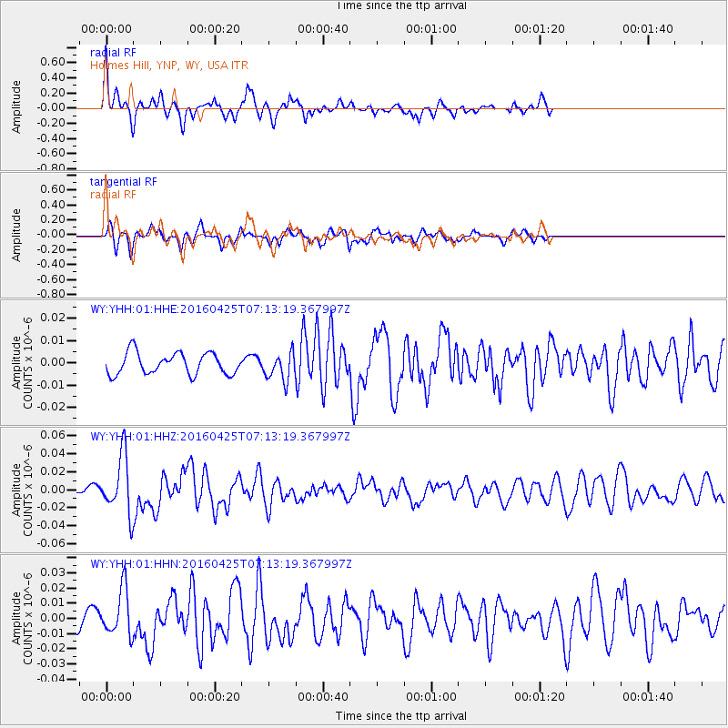
Signal To Noise
| Channel | StoN | STA | LTA |
| WY:YHH:01:HHZ:20160425T07:13:19.367997Z | 5.6938677 | 3.25886E-8 | 5.723455E-9 |
| WY:YHH:01:HHN:20160425T07:13:19.367997Z | 4.5535426 | 1.5593685E-8 | 3.4245173E-9 |
| WY:YHH:01:HHE:20160425T07:13:19.367997Z | 1.2784055 | 6.1529497E-9 | 4.8129873E-9 |
| Arrivals |
| Ps | |
| PpPs | |
| PsPs/PpSs | |


