You are here: Home > Network List > TA - USArray Transportable Network (new EarthScope stations) Stations List
> Station B18K Kokolik River, AK, USA > Earthquake Result Viewer
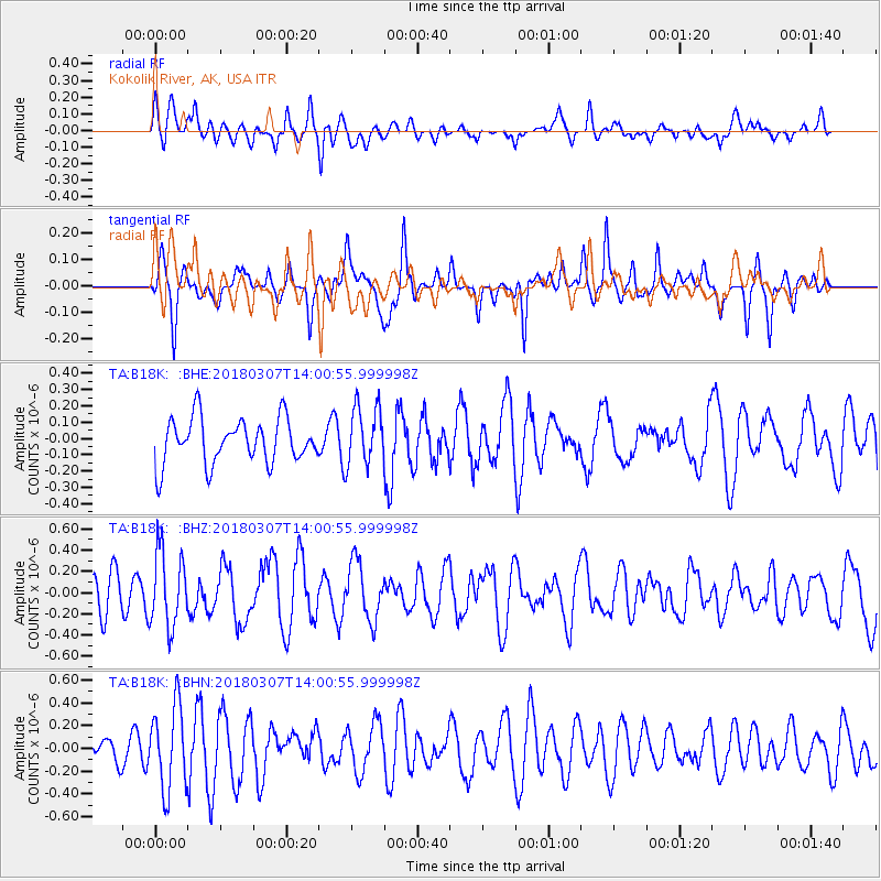
B18K Kokolik River, AK, USA - Earthquake Result Viewer
*The percent match for this event was below the threshold and hence no stack was calculated.
| Earthquake location: |
New Britain Region, P.N.G. |
| Earthquake latitude/longitude: |
-5.4/151.4 |
| Earthquake time(UTC): |
2018/03/07 (066) 13:49:17 GMT |
| Earthquake Depth: |
56 km |
| Earthquake Magnitude: |
5.6 Mww |
| Earthquake Catalog/Contributor: |
NEIC PDE/us |
|
| Network: |
TA USArray Transportable Network (new EarthScope stations) |
| Station: |
B18K Kokolik River, AK, USA |
| Lat/Lon: |
69.36 N/161.80 W |
| Elevation: |
222 m |
|
| Distance: |
81.2 deg |
| Az: |
15.161 deg |
| Baz: |
227.263 deg |
| Ray Param: |
$rayparam |
*The percent match for this event was below the threshold and hence was not used in the summary stack. |
|
| Radial Match: |
53.79798 % |
| Radial Bump: |
400 |
| Transverse Match: |
57.346348 % |
| Transverse Bump: |
385 |
| SOD ConfigId: |
13570011 |
| Insert Time: |
2019-04-29 22:31:49.309 +0000 |
| GWidth: |
2.5 |
| Max Bumps: |
400 |
| Tol: |
0.001 |
|
Signal To Noise
| Channel | StoN | STA | LTA |
| TA:B18K: :BHZ:20180307T14:00:55.999998Z | 1.6339052 | 3.5571503E-7 | 2.1770849E-7 |
| TA:B18K: :BHN:20180307T14:00:55.999998Z | 2.6394541 | 3.655374E-7 | 1.3848977E-7 |
| TA:B18K: :BHE:20180307T14:00:55.999998Z | 1.3177536 | 1.823084E-7 | 1.3834787E-7 |
| Arrivals |
| Ps | |
| PpPs | |
| PsPs/PpSs | |


