You are here: Home > Network List > TA - USArray Transportable Network (new EarthScope stations) Stations List
> Station I30M Mount Dempster, Yukon, CAN > Earthquake Result Viewer
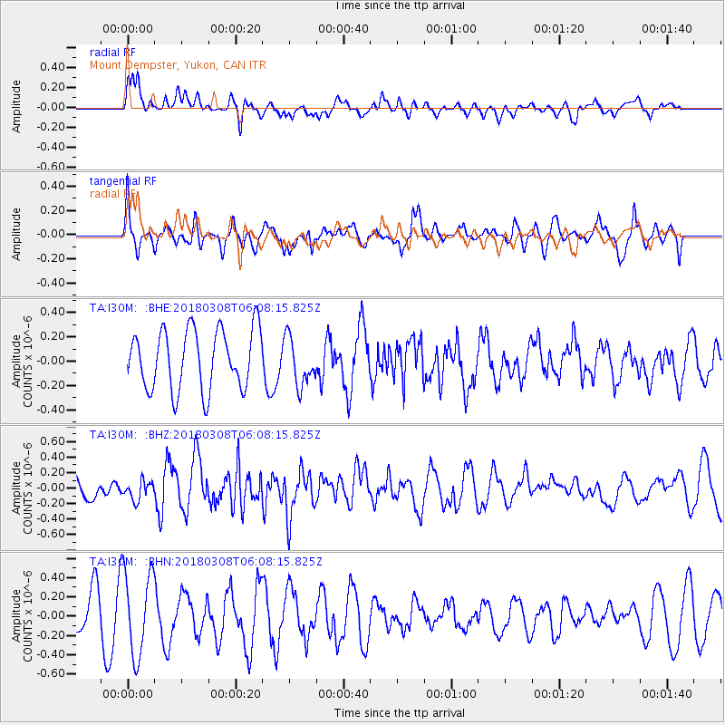
I30M Mount Dempster, Yukon, CAN - Earthquake Result Viewer
*The percent match for this event was below the threshold and hence no stack was calculated.
| Earthquake location: |
Southeast Of Honshu, Japan |
| Earthquake latitude/longitude: |
29.3/142.2 |
| Earthquake time(UTC): |
2018/03/08 (067) 05:58:38 GMT |
| Earthquake Depth: |
10 km |
| Earthquake Magnitude: |
5.2 Mww |
| Earthquake Catalog/Contributor: |
NEIC PDE/us |
|
| Network: |
TA USArray Transportable Network (new EarthScope stations) |
| Station: |
I30M Mount Dempster, Yukon, CAN |
| Lat/Lon: |
65.22 N/136.38 W |
| Elevation: |
1399 m |
|
| Distance: |
60.2 deg |
| Az: |
28.699 deg |
| Baz: |
275.752 deg |
| Ray Param: |
$rayparam |
*The percent match for this event was below the threshold and hence was not used in the summary stack. |
|
| Radial Match: |
49.796993 % |
| Radial Bump: |
400 |
| Transverse Match: |
46.353363 % |
| Transverse Bump: |
396 |
| SOD ConfigId: |
13570011 |
| Insert Time: |
2019-04-29 22:41:57.171 +0000 |
| GWidth: |
2.5 |
| Max Bumps: |
400 |
| Tol: |
0.001 |
|
Signal To Noise
| Channel | StoN | STA | LTA |
| TA:I30M: :BHZ:20180308T06:08:15.825Z | 0.6670769 | 1.2014925E-7 | 1.8011305E-7 |
| TA:I30M: :BHN:20180308T06:08:15.825Z | 2.208756 | 4.299437E-7 | 1.9465422E-7 |
| TA:I30M: :BHE:20180308T06:08:15.825Z | 0.8063909 | 1.9818194E-7 | 2.457641E-7 |
| Arrivals |
| Ps | |
| PpPs | |
| PsPs/PpSs | |


