You are here: Home > Network List > TA - USArray Transportable Network (new EarthScope stations) Stations List
> Station R32K Eaglecrest, AK, USA > Earthquake Result Viewer
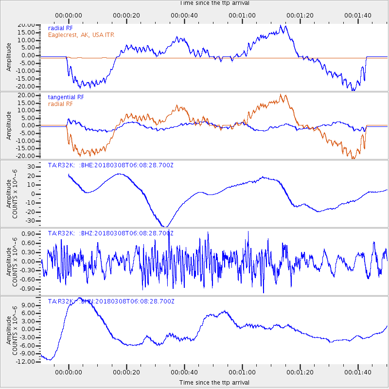
R32K Eaglecrest, AK, USA - Earthquake Result Viewer
*The percent match for this event was below the threshold and hence no stack was calculated.
| Earthquake location: |
Southeast Of Honshu, Japan |
| Earthquake latitude/longitude: |
29.3/142.2 |
| Earthquake time(UTC): |
2018/03/08 (067) 05:58:38 GMT |
| Earthquake Depth: |
10 km |
| Earthquake Magnitude: |
5.2 Mww |
| Earthquake Catalog/Contributor: |
NEIC PDE/us |
|
| Network: |
TA USArray Transportable Network (new EarthScope stations) |
| Station: |
R32K Eaglecrest, AK, USA |
| Lat/Lon: |
58.27 N/134.52 W |
| Elevation: |
386 m |
|
| Distance: |
62.1 deg |
| Az: |
36.427 deg |
| Baz: |
281.124 deg |
| Ray Param: |
$rayparam |
*The percent match for this event was below the threshold and hence was not used in the summary stack. |
|
| Radial Match: |
53.6962 % |
| Radial Bump: |
400 |
| Transverse Match: |
29.785961 % |
| Transverse Bump: |
400 |
| SOD ConfigId: |
13570011 |
| Insert Time: |
2019-04-29 22:42:13.812 +0000 |
| GWidth: |
2.5 |
| Max Bumps: |
400 |
| Tol: |
0.001 |
|
Signal To Noise
| Channel | StoN | STA | LTA |
| TA:R32K: :BHZ:20180308T06:08:28.700Z | 1.0589058 | 2.5592934E-7 | 2.4169228E-7 |
| TA:R32K: :BHN:20180308T06:08:28.700Z | 1.6042371 | 1.3700761E-5 | 8.540359E-6 |
| TA:R32K: :BHE:20180308T06:08:28.700Z | 6.427406 | 4.39392E-5 | 6.8362256E-6 |
| Arrivals |
| Ps | |
| PpPs | |
| PsPs/PpSs | |


