You are here: Home > Network List > TA - USArray Transportable Network (new EarthScope stations) Stations List
> Station R19A Curley Farm, La Sal, UT, USA > Earthquake Result Viewer
R19A Curley Farm, La Sal, UT, USA - Earthquake Result Viewer
| Earthquake location: |
Windward Islands |
| Earthquake latitude/longitude: |
15.0/-61.3 |
| Earthquake time(UTC): |
2007/11/29 (333) 19:00:19 GMT |
| Earthquake Depth: |
148 km |
| Earthquake Magnitude: |
6.9 MB, 7.4 MW, 7.4 MW |
| Earthquake Catalog/Contributor: |
WHDF/NEIC |
|
| Network: |
TA USArray Transportable Network (new EarthScope stations) |
| Station: |
R19A Curley Farm, La Sal, UT, USA |
| Lat/Lon: |
38.29 N/109.26 W |
| Elevation: |
2035 m |
|
| Distance: |
48.1 deg |
| Az: |
308.265 deg |
| Baz: |
105.343 deg |
| Ray Param: |
0.06902178 |
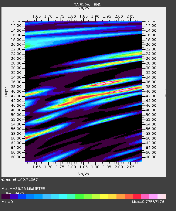
| Estimated Moho Depth: |
36.25 km |
| Estimated Crust Vp/Vs: |
1.94 |
| Assumed Crust Vp: |
6.291 km/s |
| Estimated Crust Vs: |
3.238 km/s |
| Estimated Crust Poisson's Ratio: |
0.32 |
|
| Radial Match: |
92.74067 % |
| Radial Bump: |
400 |
| Transverse Match: |
79.45169 % |
| Transverse Bump: |
400 |
| SOD ConfigId: |
2564 |
| Insert Time: |
2010-03-06 09:44:37.388 +0000 |
| GWidth: |
2.5 |
| Max Bumps: |
400 |
| Tol: |
0.001 |
|

Signal To Noise
| Channel | StoN | STA | LTA |
| TA:R19A: :BHN:20071129T19:08:14.199011Z | 6.435462 | 1.2580538E-6 | 1.9548771E-7 |
| TA:R19A: :BHE:20071129T19:08:14.199011Z | 18.143316 | 4.584213E-6 | 2.5266675E-7 |
| TA:R19A: :BHZ:20071129T19:08:14.199011Z | 33.951168 | 1.0890305E-5 | 3.2076377E-7 |
| Arrivals |
| Ps | 5.7 SECOND |
| PpPs | 16 SECOND |
| PsPs/PpSs | 22 SECOND |


