You are here: Home > Network List > AU - Australian Seismological Centre Stations List
> Station MORW Morawa, Western Australia > Earthquake Result Viewer
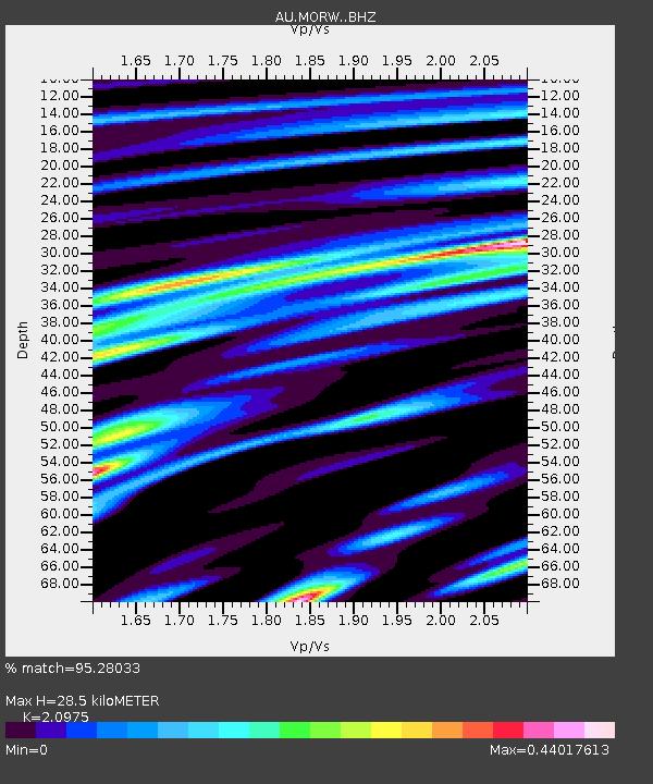
MORW Morawa, Western Australia - Earthquake Result Viewer
| Earthquake location: |
New Ireland Region, P.N.G. |
| Earthquake latitude/longitude: |
-4.4/153.2 |
| Earthquake time(UTC): |
2018/03/08 (067) 17:39:50 GMT |
| Earthquake Depth: |
15 km |
| Earthquake Magnitude: |
6.8 mww |
| Earthquake Catalog/Contributor: |
NEIC PDE/us |
|
| Network: |
AU Australian Seismological Centre |
| Station: |
MORW Morawa, Western Australia |
| Lat/Lon: |
29.07 S/116.04 E |
| Elevation: |
296 m |
|
| Distance: |
42.9 deg |
| Az: |
230.954 deg |
| Baz: |
62.201 deg |
| Ray Param: |
0.07287283 |
| Estimated Moho Depth: |
28.5 km |
| Estimated Crust Vp/Vs: |
2.10 |
| Assumed Crust Vp: |
6.459 km/s |
| Estimated Crust Vs: |
3.08 km/s |
| Estimated Crust Poisson's Ratio: |
0.35 |
|
| Radial Match: |
95.28033 % |
| Radial Bump: |
239 |
| Transverse Match: |
73.37722 % |
| Transverse Bump: |
400 |
| SOD ConfigId: |
13570011 |
| Insert Time: |
2019-04-29 22:54:43.064 +0000 |
| GWidth: |
2.5 |
| Max Bumps: |
400 |
| Tol: |
0.001 |
|

Signal To Noise
| Channel | StoN | STA | LTA |
| AU:MORW: :BHZ:20180308T17:47:17.144003Z | 18.490732 | 3.649711E-6 | 1.9738054E-7 |
| AU:MORW: :BHN:20180308T17:47:17.144003Z | 5.691062 | 1.1202628E-6 | 1.96846E-7 |
| AU:MORW: :BHE:20180308T17:47:17.144003Z | 10.643409 | 1.8923531E-6 | 1.7779577E-7 |
| Arrivals |
| Ps | 5.1 SECOND |
| PpPs | 13 SECOND |
| PsPs/PpSs | 18 SECOND |


