You are here: Home > Network List > AU - Australian Seismological Centre Stations List
> Station TOO Toolangi, Victoria > Earthquake Result Viewer
TOO Toolangi, Victoria - Earthquake Result Viewer
| Earthquake location: |
New Ireland Region, P.N.G. |
| Earthquake latitude/longitude: |
-4.4/153.2 |
| Earthquake time(UTC): |
2018/03/08 (067) 17:39:50 GMT |
| Earthquake Depth: |
15 km |
| Earthquake Magnitude: |
6.8 mww |
| Earthquake Catalog/Contributor: |
NEIC PDE/us |
|
| Network: |
AU Australian Seismological Centre |
| Station: |
TOO Toolangi, Victoria |
| Lat/Lon: |
37.57 S/145.49 E |
| Elevation: |
604 m |
|
| Distance: |
33.8 deg |
| Az: |
191.057 deg |
| Baz: |
13.926 deg |
| Ray Param: |
0.07804282 |
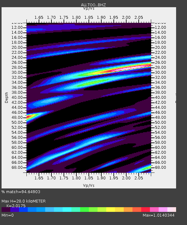
| Estimated Moho Depth: |
28.0 km |
| Estimated Crust Vp/Vs: |
2.02 |
| Assumed Crust Vp: |
6.577 km/s |
| Estimated Crust Vs: |
3.26 km/s |
| Estimated Crust Poisson's Ratio: |
0.34 |
|
| Radial Match: |
94.64903 % |
| Radial Bump: |
264 |
| Transverse Match: |
72.62529 % |
| Transverse Bump: |
400 |
| SOD ConfigId: |
13570011 |
| Insert Time: |
2019-04-29 22:54:47.956 +0000 |
| GWidth: |
2.5 |
| Max Bumps: |
400 |
| Tol: |
0.001 |
|

Signal To Noise
| Channel | StoN | STA | LTA |
| AU:TOO: :BHZ:20180308T17:46:00.519003Z | 61.392784 | 9.860885E-6 | 1.606196E-7 |
| AU:TOO: :BHN:20180308T17:46:00.519003Z | 49.912357 | 6.5248637E-6 | 1.3072642E-7 |
| AU:TOO: :BHE:20180308T17:46:00.519003Z | 11.573884 | 1.635005E-6 | 1.4126675E-7 |
| Arrivals |
| Ps | 4.7 SECOND |
| PpPs | 12 SECOND |
| PsPs/PpSs | 17 SECOND |


