You are here: Home > Network List > IU - Global Seismograph Network (GSN - IRIS/USGS) Stations List
> Station XMAS Kiritimati Island, Republic of Kiribati > Earthquake Result Viewer
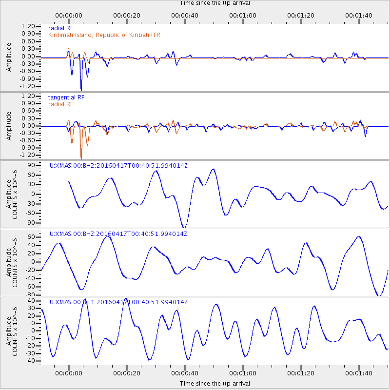
XMAS Kiritimati Island, Republic of Kiribati - Earthquake Result Viewer
*The percent match for this event was below the threshold and hence no stack was calculated.
| Earthquake location: |
Near Coast Of Ecuador |
| Earthquake latitude/longitude: |
-0.3/-80.5 |
| Earthquake time(UTC): |
2016/04/17 (108) 00:29:31 GMT |
| Earthquake Depth: |
16 km |
| Earthquake Magnitude: |
5.5 MB |
| Earthquake Catalog/Contributor: |
NEIC PDE/NEIC COMCAT |
|
| Network: |
IU Global Seismograph Network (GSN - IRIS/USGS) |
| Station: |
XMAS Kiritimati Island, Republic of Kiribati |
| Lat/Lon: |
2.04 N/157.45 W |
| Elevation: |
20 m |
|
| Distance: |
77.0 deg |
| Az: |
272.145 deg |
| Baz: |
90.739 deg |
| Ray Param: |
$rayparam |
*The percent match for this event was below the threshold and hence was not used in the summary stack. |
|
| Radial Match: |
87.271484 % |
| Radial Bump: |
281 |
| Transverse Match: |
46.59152 % |
| Transverse Bump: |
400 |
| SOD ConfigId: |
1475611 |
| Insert Time: |
2016-05-10 22:11:29.998 +0000 |
| GWidth: |
2.5 |
| Max Bumps: |
400 |
| Tol: |
0.001 |
|
Signal To Noise
| Channel | StoN | STA | LTA |
| IU:XMAS:00:BHZ:20160417T00:40:51.994014Z | 1.5962577 | 3.9641178E-5 | 2.4833822E-5 |
| IU:XMAS:00:BH1:20160417T00:40:51.994014Z | 0.5372389 | 1.3349763E-5 | 2.484884E-5 |
| IU:XMAS:00:BH2:20160417T00:40:51.994014Z | 1.7599996 | 5.04672E-5 | 2.8674549E-5 |
| Arrivals |
| Ps | |
| PpPs | |
| PsPs/PpSs | |


