You are here: Home > Network List > TA - USArray Transportable Network (new EarthScope stations) Stations List
> Station I21K Tanana, AK, USA > Earthquake Result Viewer
I21K Tanana, AK, USA - Earthquake Result Viewer
| Earthquake location: |
New Ireland Region, P.N.G. |
| Earthquake latitude/longitude: |
-4.4/153.2 |
| Earthquake time(UTC): |
2018/03/08 (067) 17:39:50 GMT |
| Earthquake Depth: |
15 km |
| Earthquake Magnitude: |
6.8 mww |
| Earthquake Catalog/Contributor: |
NEIC PDE/us |
|
| Network: |
TA USArray Transportable Network (new EarthScope stations) |
| Station: |
I21K Tanana, AK, USA |
| Lat/Lon: |
65.18 N/151.98 W |
| Elevation: |
248 m |
|
| Distance: |
80.0 deg |
| Az: |
20.506 deg |
| Baz: |
235.844 deg |
| Ray Param: |
0.048564475 |
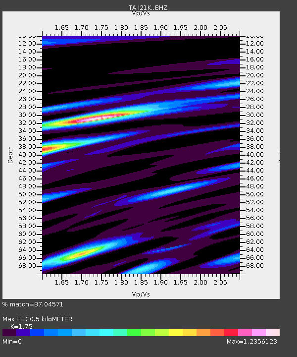
| Estimated Moho Depth: |
30.5 km |
| Estimated Crust Vp/Vs: |
1.75 |
| Assumed Crust Vp: |
6.566 km/s |
| Estimated Crust Vs: |
3.752 km/s |
| Estimated Crust Poisson's Ratio: |
0.26 |
|
| Radial Match: |
87.04571 % |
| Radial Bump: |
351 |
| Transverse Match: |
72.73907 % |
| Transverse Bump: |
400 |
| SOD ConfigId: |
13570011 |
| Insert Time: |
2019-04-29 22:58:18.046 +0000 |
| GWidth: |
2.5 |
| Max Bumps: |
400 |
| Tol: |
0.001 |
|

Signal To Noise
| Channel | StoN | STA | LTA |
| TA:I21K: :BHZ:20180308T17:51:27.299978Z | 2.805599 | 1.2184929E-6 | 4.343076E-7 |
| TA:I21K: :BHN:20180308T17:51:27.299978Z | 1.4998959 | 8.885535E-7 | 5.924101E-7 |
| TA:I21K: :BHE:20180308T17:51:27.299978Z | 0.74005586 | 3.2530951E-7 | 4.3957425E-7 |
| Arrivals |
| Ps | 3.6 SECOND |
| PpPs | 12 SECOND |
| PsPs/PpSs | 16 SECOND |


