You are here: Home > Network List > TA - USArray Transportable Network (new EarthScope stations) Stations List
> Station J29N Klondike Camp, Yukon, CA > Earthquake Result Viewer
J29N Klondike Camp, Yukon, CA - Earthquake Result Viewer
| Earthquake location: |
New Ireland Region, P.N.G. |
| Earthquake latitude/longitude: |
-4.4/153.2 |
| Earthquake time(UTC): |
2018/03/08 (067) 17:39:50 GMT |
| Earthquake Depth: |
15 km |
| Earthquake Magnitude: |
6.8 mww |
| Earthquake Catalog/Contributor: |
NEIC PDE/us |
|
| Network: |
TA USArray Transportable Network (new EarthScope stations) |
| Station: |
J29N Klondike Camp, Yukon, CA |
| Lat/Lon: |
64.45 N/138.22 W |
| Elevation: |
982 m |
|
| Distance: |
84.9 deg |
| Az: |
23.91 deg |
| Baz: |
248.745 deg |
| Ray Param: |
0.045162395 |
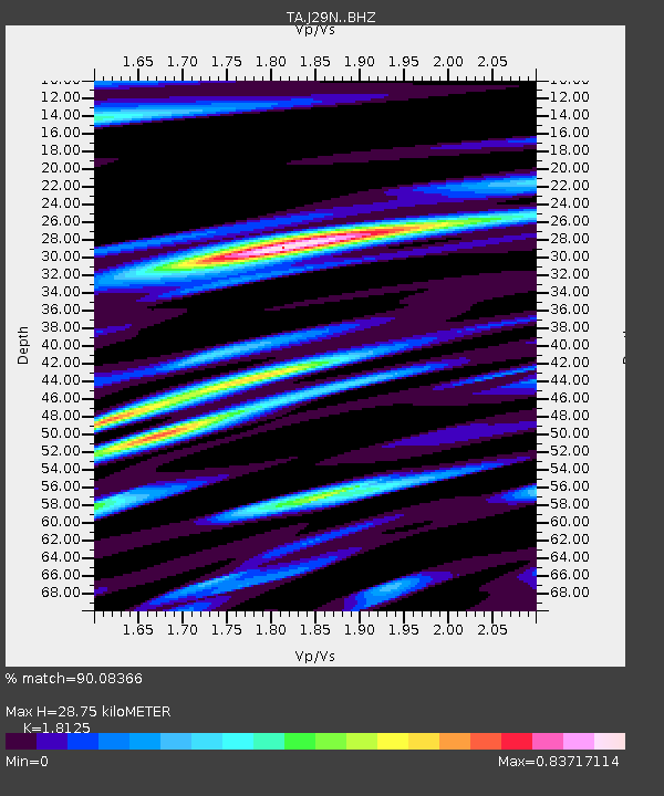
| Estimated Moho Depth: |
28.75 km |
| Estimated Crust Vp/Vs: |
1.81 |
| Assumed Crust Vp: |
6.566 km/s |
| Estimated Crust Vs: |
3.623 km/s |
| Estimated Crust Poisson's Ratio: |
0.28 |
|
| Radial Match: |
90.08366 % |
| Radial Bump: |
400 |
| Transverse Match: |
69.71239 % |
| Transverse Bump: |
400 |
| SOD ConfigId: |
13570011 |
| Insert Time: |
2019-04-29 22:58:26.945 +0000 |
| GWidth: |
2.5 |
| Max Bumps: |
400 |
| Tol: |
0.001 |
|

Signal To Noise
| Channel | StoN | STA | LTA |
| TA:J29N: :BHZ:20180308T17:51:52.62499Z | 2.4087512 | 6.7199903E-7 | 2.7898233E-7 |
| TA:J29N: :BHN:20180308T17:51:52.62499Z | 0.9594736 | 3.3294026E-7 | 3.4700304E-7 |
| TA:J29N: :BHE:20180308T17:51:52.62499Z | 1.5397618 | 2.8394717E-7 | 1.844098E-7 |
| Arrivals |
| Ps | 3.6 SECOND |
| PpPs | 12 SECOND |
| PsPs/PpSs | 16 SECOND |


