You are here: Home > Network List > TA - USArray Transportable Network (new EarthScope stations) Stations List
> Station M26K Nabesna, AK, USA > Earthquake Result Viewer
M26K Nabesna, AK, USA - Earthquake Result Viewer
| Earthquake location: |
New Ireland Region, P.N.G. |
| Earthquake latitude/longitude: |
-4.4/153.2 |
| Earthquake time(UTC): |
2018/03/08 (067) 17:39:50 GMT |
| Earthquake Depth: |
15 km |
| Earthquake Magnitude: |
6.8 mww |
| Earthquake Catalog/Contributor: |
NEIC PDE/us |
|
| Network: |
TA USArray Transportable Network (new EarthScope stations) |
| Station: |
M26K Nabesna, AK, USA |
| Lat/Lon: |
62.40 N/143.00 W |
| Elevation: |
888 m |
|
| Distance: |
82.1 deg |
| Az: |
24.955 deg |
| Baz: |
244.594 deg |
| Ray Param: |
0.047124222 |
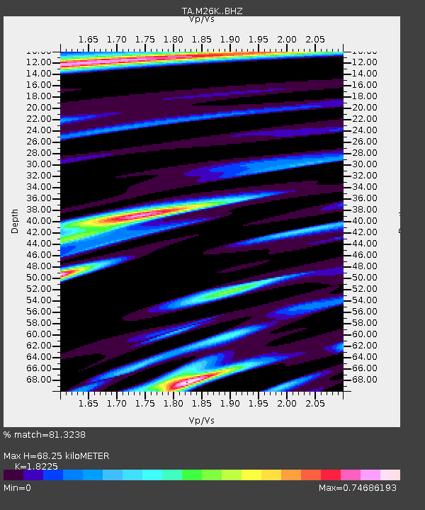
| Estimated Moho Depth: |
68.25 km |
| Estimated Crust Vp/Vs: |
1.82 |
| Assumed Crust Vp: |
6.566 km/s |
| Estimated Crust Vs: |
3.603 km/s |
| Estimated Crust Poisson's Ratio: |
0.28 |
|
| Radial Match: |
81.3238 % |
| Radial Bump: |
400 |
| Transverse Match: |
74.185425 % |
| Transverse Bump: |
400 |
| SOD ConfigId: |
13570011 |
| Insert Time: |
2019-04-29 22:58:44.158 +0000 |
| GWidth: |
2.5 |
| Max Bumps: |
400 |
| Tol: |
0.001 |
|

Signal To Noise
| Channel | StoN | STA | LTA |
| TA:M26K: :BHZ:20180308T17:51:38.350027Z | 2.1458216 | 4.956918E-7 | 2.3100326E-7 |
| TA:M26K: :BHN:20180308T17:51:38.350027Z | 1.3494419 | 4.829367E-7 | 3.5787883E-7 |
| TA:M26K: :BHE:20180308T17:51:38.350027Z | 2.223536 | 2.887763E-7 | 1.2987256E-7 |
| Arrivals |
| Ps | 8.8 SECOND |
| PpPs | 29 SECOND |
| PsPs/PpSs | 37 SECOND |


