You are here: Home > Network List > TA - USArray Transportable Network (new EarthScope stations) Stations List
> Station R19A Curley Farm, La Sal, UT, USA > Earthquake Result Viewer
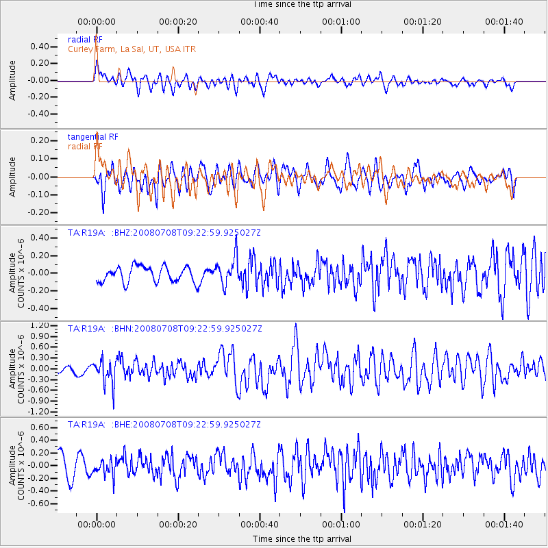
R19A Curley Farm, La Sal, UT, USA - Earthquake Result Viewer
*The percent match for this event was below the threshold and hence no stack was calculated.
| Earthquake location: |
Southern Peru |
| Earthquake latitude/longitude: |
-16.0/-71.7 |
| Earthquake time(UTC): |
2008/07/08 (190) 09:13:07 GMT |
| Earthquake Depth: |
123 km |
| Earthquake Magnitude: |
5.8 MB, 6.2 MW, 6.2 MW |
| Earthquake Catalog/Contributor: |
WHDF/NEIC |
|
| Network: |
TA USArray Transportable Network (new EarthScope stations) |
| Station: |
R19A Curley Farm, La Sal, UT, USA |
| Lat/Lon: |
38.29 N/109.26 W |
| Elevation: |
2035 m |
|
| Distance: |
64.4 deg |
| Az: |
327.917 deg |
| Baz: |
139.517 deg |
| Ray Param: |
$rayparam |
*The percent match for this event was below the threshold and hence was not used in the summary stack. |
|
| Radial Match: |
52.099323 % |
| Radial Bump: |
400 |
| Transverse Match: |
65.92472 % |
| Transverse Bump: |
400 |
| SOD ConfigId: |
2504 |
| Insert Time: |
2010-03-06 09:46:10.888 +0000 |
| GWidth: |
2.5 |
| Max Bumps: |
400 |
| Tol: |
0.001 |
|
Signal To Noise
| Channel | StoN | STA | LTA |
| TA:R19A: :BHN:20080708T09:22:59.925027Z | 3.5266337 | 3.4071056E-7 | 9.66107E-8 |
| TA:R19A: :BHE:20080708T09:22:59.925027Z | 0.7985627 | 1.2385983E-7 | 1.5510345E-7 |
| TA:R19A: :BHZ:20080708T09:22:59.925027Z | 1.8047634 | 1.6060228E-7 | 8.8987996E-8 |
| Arrivals |
| Ps | |
| PpPs | |
| PsPs/PpSs | |


