You are here: Home > Network List > TA - USArray Transportable Network (new EarthScope stations) Stations List
> Station R19A Curley Farm, La Sal, UT, USA > Earthquake Result Viewer
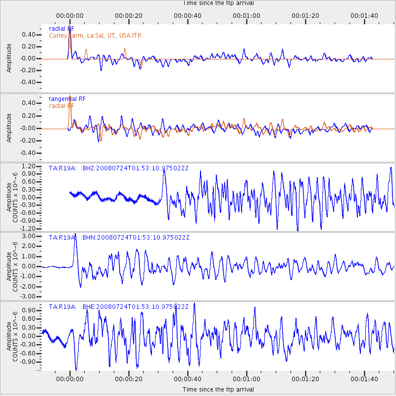
R19A Curley Farm, La Sal, UT, USA - Earthquake Result Viewer
*The percent match for this event was below the threshold and hence no stack was calculated.
| Earthquake location: |
Kuril Islands |
| Earthquake latitude/longitude: |
51.0/157.6 |
| Earthquake time(UTC): |
2008/07/24 (206) 01:43:16 GMT |
| Earthquake Depth: |
27 km |
| Earthquake Magnitude: |
6.0 MB, 6.0 MS, 6.2 MW, 6.2 MW |
| Earthquake Catalog/Contributor: |
WHDF/NEIC |
|
| Network: |
TA USArray Transportable Network (new EarthScope stations) |
| Station: |
R19A Curley Farm, La Sal, UT, USA |
| Lat/Lon: |
38.29 N/109.26 W |
| Elevation: |
2035 m |
|
| Distance: |
63.2 deg |
| Az: |
61.66 deg |
| Baz: |
314.988 deg |
| Ray Param: |
$rayparam |
*The percent match for this event was below the threshold and hence was not used in the summary stack. |
|
| Radial Match: |
78.06807 % |
| Radial Bump: |
400 |
| Transverse Match: |
79.22429 % |
| Transverse Bump: |
400 |
| SOD ConfigId: |
2504 |
| Insert Time: |
2010-03-06 09:46:17.978 +0000 |
| GWidth: |
2.5 |
| Max Bumps: |
400 |
| Tol: |
0.001 |
|
Signal To Noise
| Channel | StoN | STA | LTA |
| TA:R19A: :BHN:20080724T01:53:10.975022Z | 18.884123 | 1.3647297E-6 | 7.226863E-8 |
| TA:R19A: :BHE:20080724T01:53:10.975022Z | 4.515157 | 4.522421E-7 | 1.00160875E-7 |
| TA:R19A: :BHZ:20080724T01:53:10.975022Z | 4.311604 | 4.7459818E-7 | 1.1007462E-7 |
| Arrivals |
| Ps | |
| PpPs | |
| PsPs/PpSs | |


