You are here: Home > Network List > TA - USArray Transportable Network (new EarthScope stations) Stations List
> Station G31M Satah River, YT, CAN > Earthquake Result Viewer
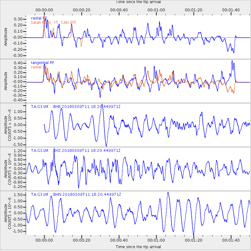
G31M Satah River, YT, CAN - Earthquake Result Viewer
*The percent match for this event was below the threshold and hence no stack was calculated.
| Earthquake location: |
New Ireland Region, P.N.G. |
| Earthquake latitude/longitude: |
-4.3/153.3 |
| Earthquake time(UTC): |
2018/03/09 (068) 11:06:10 GMT |
| Earthquake Depth: |
46 km |
| Earthquake Magnitude: |
5.8 Mww |
| Earthquake Catalog/Contributor: |
NEIC PDE/us |
|
| Network: |
TA USArray Transportable Network (new EarthScope stations) |
| Station: |
G31M Satah River, YT, CAN |
| Lat/Lon: |
66.92 N/134.27 W |
| Elevation: |
61 m |
|
| Distance: |
87.2 deg |
| Az: |
22.099 deg |
| Baz: |
252.105 deg |
| Ray Param: |
$rayparam |
*The percent match for this event was below the threshold and hence was not used in the summary stack. |
|
| Radial Match: |
40.498585 % |
| Radial Bump: |
368 |
| Transverse Match: |
52.27868 % |
| Transverse Bump: |
351 |
| SOD ConfigId: |
13570011 |
| Insert Time: |
2019-04-29 23:04:25.067 +0000 |
| GWidth: |
2.5 |
| Max Bumps: |
400 |
| Tol: |
0.001 |
|
Signal To Noise
| Channel | StoN | STA | LTA |
| TA:G31M: :BHZ:20180309T11:18:20.449971Z | 1.4692146 | 4.8676003E-7 | 3.3130632E-7 |
| TA:G31M: :BHN:20180309T11:18:20.449971Z | 2.1645575 | 8.088772E-7 | 3.7369173E-7 |
| TA:G31M: :BHE:20180309T11:18:20.449971Z | 1.7257758 | 1.0109372E-6 | 5.857871E-7 |
| Arrivals |
| Ps | |
| PpPs | |
| PsPs/PpSs | |


