You are here: Home > Network List > IW - Intermountain West Stations List
> Station PLID Pearl Lake, Idaho, USA > Earthquake Result Viewer
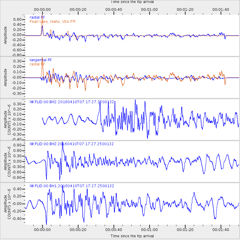
PLID Pearl Lake, Idaho, USA - Earthquake Result Viewer
*The percent match for this event was below the threshold and hence no stack was calculated.
| Earthquake location: |
Oaxaca, Mexico |
| Earthquake latitude/longitude: |
16.1/-96.3 |
| Earthquake time(UTC): |
2016/04/10 (101) 07:11:21 GMT |
| Earthquake Depth: |
25 km |
| Earthquake Magnitude: |
5.5 MWW, 5.2 MWB, 5.5 MWC |
| Earthquake Catalog/Contributor: |
NEIC PDE/NEIC COMCAT |
|
| Network: |
IW Intermountain West |
| Station: |
PLID Pearl Lake, Idaho, USA |
| Lat/Lon: |
45.09 N/116.00 W |
| Elevation: |
2164 m |
|
| Distance: |
33.4 deg |
| Az: |
334.215 deg |
| Baz: |
143.814 deg |
| Ray Param: |
$rayparam |
*The percent match for this event was below the threshold and hence was not used in the summary stack. |
|
| Radial Match: |
58.042007 % |
| Radial Bump: |
400 |
| Transverse Match: |
55.320915 % |
| Transverse Bump: |
400 |
| SOD ConfigId: |
1475611 |
| Insert Time: |
2016-05-11 10:58:30.320 +0000 |
| GWidth: |
2.5 |
| Max Bumps: |
400 |
| Tol: |
0.001 |
|
Signal To Noise
| Channel | StoN | STA | LTA |
| IW:PLID:00:BHZ:20160410T07:17:27.250013Z | 2.5084603 | 3.3450726E-7 | 1.3335163E-7 |
| IW:PLID:00:BH1:20160410T07:17:27.250013Z | 2.6495714 | 2.3710379E-7 | 8.94876E-8 |
| IW:PLID:00:BH2:20160410T07:17:27.250013Z | 2.7169504 | 1.442236E-7 | 5.30829E-8 |
| Arrivals |
| Ps | |
| PpPs | |
| PsPs/PpSs | |


