You are here: Home > Network List > CI - Caltech Regional Seismic Network Stations List
> Station MPM Manuel Prospect Mine, California, USA > Earthquake Result Viewer
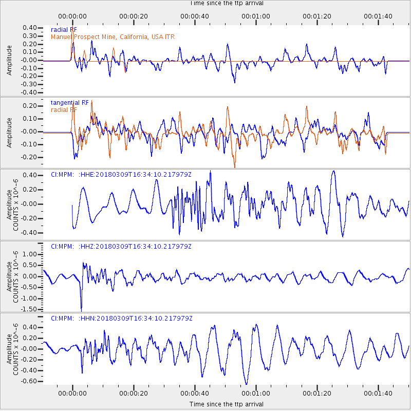
MPM Manuel Prospect Mine, California, USA - Earthquake Result Viewer
*The percent match for this event was below the threshold and hence no stack was calculated.
| Earthquake location: |
Fiji Islands Region |
| Earthquake latitude/longitude: |
-21.1/-178.5 |
| Earthquake time(UTC): |
2018/03/09 (068) 16:23:22 GMT |
| Earthquake Depth: |
539 km |
| Earthquake Magnitude: |
5.7 Mww |
| Earthquake Catalog/Contributor: |
NEIC PDE/us |
|
| Network: |
CI Caltech Regional Seismic Network |
| Station: |
MPM Manuel Prospect Mine, California, USA |
| Lat/Lon: |
36.06 N/117.49 W |
| Elevation: |
185 m |
|
| Distance: |
81.0 deg |
| Az: |
45.885 deg |
| Baz: |
235.832 deg |
| Ray Param: |
$rayparam |
*The percent match for this event was below the threshold and hence was not used in the summary stack. |
|
| Radial Match: |
66.43869 % |
| Radial Bump: |
400 |
| Transverse Match: |
47.424377 % |
| Transverse Bump: |
400 |
| SOD ConfigId: |
13570011 |
| Insert Time: |
2019-04-29 23:08:31.855 +0000 |
| GWidth: |
2.5 |
| Max Bumps: |
400 |
| Tol: |
0.001 |
|
Signal To Noise
| Channel | StoN | STA | LTA |
| CI:MPM: :HHZ:20180309T16:34:10.217979Z | 1.8047373 | 4.7079433E-7 | 2.6086585E-7 |
| CI:MPM: :HHN:20180309T16:34:10.217979Z | 1.1098704 | 1.2259311E-7 | 1.1045713E-7 |
| CI:MPM: :HHE:20180309T16:34:10.217979Z | 0.820101 | 1.13633604E-7 | 1.385605E-7 |
| Arrivals |
| Ps | |
| PpPs | |
| PsPs/PpSs | |


