You are here: Home > Network List > TA - USArray Transportable Network (new EarthScope stations) Stations List
> Station R19A Curley Farm, La Sal, UT, USA > Earthquake Result Viewer
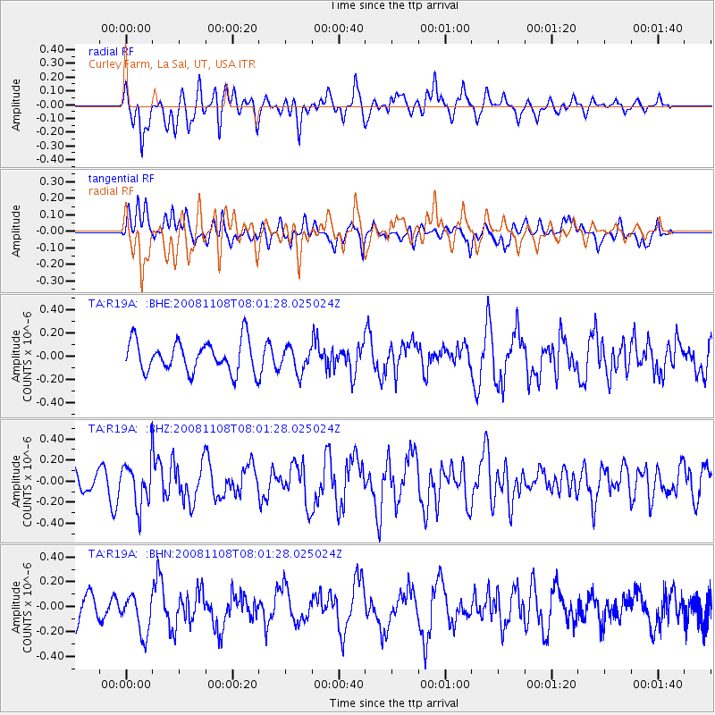
R19A Curley Farm, La Sal, UT, USA - Earthquake Result Viewer
*The percent match for this event was below the threshold and hence no stack was calculated.
| Earthquake location: |
Tonga Islands |
| Earthquake latitude/longitude: |
-15.2/-174.2 |
| Earthquake time(UTC): |
2008/11/08 (313) 07:49:59 GMT |
| Earthquake Depth: |
121 km |
| Earthquake Magnitude: |
6.0 MW, 5.4 MB, 6.0 MW |
| Earthquake Catalog/Contributor: |
WHDF/NEIC |
|
| Network: |
TA USArray Transportable Network (new EarthScope stations) |
| Station: |
R19A Curley Farm, La Sal, UT, USA |
| Lat/Lon: |
38.29 N/109.26 W |
| Elevation: |
2035 m |
|
| Distance: |
80.8 deg |
| Az: |
46.248 deg |
| Baz: |
242.396 deg |
| Ray Param: |
$rayparam |
*The percent match for this event was below the threshold and hence was not used in the summary stack. |
|
| Radial Match: |
65.35595 % |
| Radial Bump: |
400 |
| Transverse Match: |
51.89029 % |
| Transverse Bump: |
400 |
| SOD ConfigId: |
2658 |
| Insert Time: |
2010-03-06 09:47:00.700 +0000 |
| GWidth: |
2.5 |
| Max Bumps: |
400 |
| Tol: |
0.001 |
|
Signal To Noise
| Channel | StoN | STA | LTA |
| TA:R19A: :BHZ:20081108T08:01:28.025024Z | 1.7551619 | 2.0567339E-7 | 1.17182005E-7 |
| TA:R19A: :BHN:20081108T08:01:28.025024Z | 1.4598355 | 1.6451489E-7 | 1.12694124E-7 |
| TA:R19A: :BHE:20081108T08:01:28.025024Z | 0.799609 | 1.0627429E-7 | 1.3290783E-7 |
| Arrivals |
| Ps | |
| PpPs | |
| PsPs/PpSs | |


