You are here: Home > Network List > TA - USArray Transportable Network (new EarthScope stations) Stations List
> Station R19A Curley Farm, La Sal, UT, USA > Earthquake Result Viewer
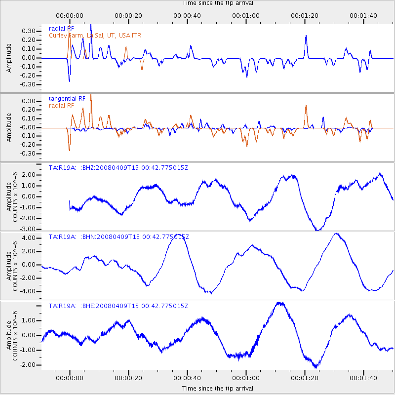
R19A Curley Farm, La Sal, UT, USA - Earthquake Result Viewer
*The percent match for this event was below the threshold and hence no stack was calculated.
| Earthquake location: |
Vanuatu Islands |
| Earthquake latitude/longitude: |
-20.0/168.9 |
| Earthquake time(UTC): |
2008/04/09 (100) 14:47:50 GMT |
| Earthquake Depth: |
35 km |
| Earthquake Magnitude: |
5.9 MB, 6.2 MS, 6.3 MW |
| Earthquake Catalog/Contributor: |
WHDF/NEIC |
|
| Network: |
TA USArray Transportable Network (new EarthScope stations) |
| Station: |
R19A Curley Farm, La Sal, UT, USA |
| Lat/Lon: |
38.29 N/109.26 W |
| Elevation: |
2035 m |
|
| Distance: |
96.0 deg |
| Az: |
51.564 deg |
| Baz: |
249.417 deg |
| Ray Param: |
$rayparam |
*The percent match for this event was below the threshold and hence was not used in the summary stack. |
|
| Radial Match: |
83.96107 % |
| Radial Bump: |
400 |
| Transverse Match: |
64.267944 % |
| Transverse Bump: |
385 |
| SOD ConfigId: |
2504 |
| Insert Time: |
2010-03-06 09:47:13.002 +0000 |
| GWidth: |
2.5 |
| Max Bumps: |
400 |
| Tol: |
0.001 |
|
Signal To Noise
| Channel | StoN | STA | LTA |
| TA:R19A: :BHN:20080409T15:00:42.775015Z | 1.4314162 | 9.77451E-7 | 6.8285595E-7 |
| TA:R19A: :BHE:20080409T15:00:42.775015Z | 0.44171494 | 2.442587E-7 | 5.529781E-7 |
| TA:R19A: :BHZ:20080409T15:00:42.775015Z | 1.8055122 | 1.0670797E-6 | 5.9101217E-7 |
| Arrivals |
| Ps | |
| PpPs | |
| PsPs/PpSs | |


