You are here: Home > Network List > US - United States National Seismic Network Stations List
> Station EGMT Eagleton, Montana, USA > Earthquake Result Viewer
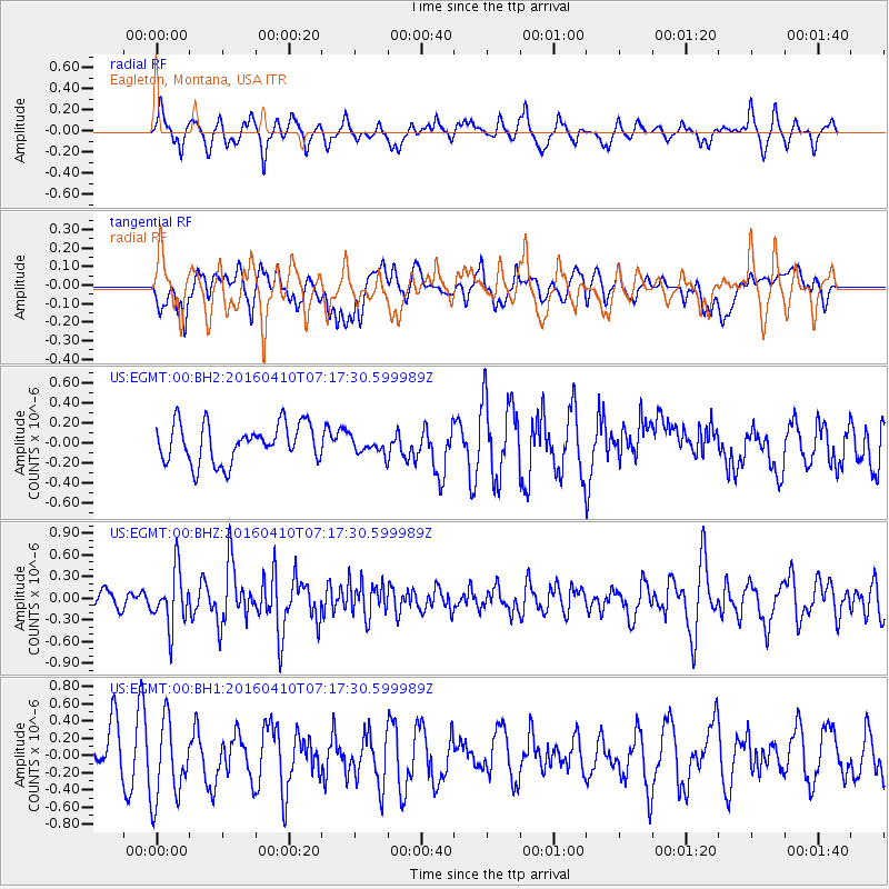
EGMT Eagleton, Montana, USA - Earthquake Result Viewer
*The percent match for this event was below the threshold and hence no stack was calculated.
| Earthquake location: |
Oaxaca, Mexico |
| Earthquake latitude/longitude: |
16.1/-96.3 |
| Earthquake time(UTC): |
2016/04/10 (101) 07:11:21 GMT |
| Earthquake Depth: |
25 km |
| Earthquake Magnitude: |
5.5 MWW, 5.2 MWB, 5.5 MWC |
| Earthquake Catalog/Contributor: |
NEIC PDE/NEIC COMCAT |
|
| Network: |
US United States National Seismic Network |
| Station: |
EGMT Eagleton, Montana, USA |
| Lat/Lon: |
48.02 N/109.75 W |
| Elevation: |
1055 m |
|
| Distance: |
33.8 deg |
| Az: |
343.624 deg |
| Baz: |
156.183 deg |
| Ray Param: |
$rayparam |
*The percent match for this event was below the threshold and hence was not used in the summary stack. |
|
| Radial Match: |
57.06759 % |
| Radial Bump: |
363 |
| Transverse Match: |
42.16093 % |
| Transverse Bump: |
400 |
| SOD ConfigId: |
1475611 |
| Insert Time: |
2016-05-11 10:59:17.197 +0000 |
| GWidth: |
2.5 |
| Max Bumps: |
400 |
| Tol: |
0.001 |
|
Signal To Noise
| Channel | StoN | STA | LTA |
| US:EGMT:00:BHZ:20160410T07:17:30.599989Z | 4.310266 | 3.8096127E-7 | 8.838463E-8 |
| US:EGMT:00:BH1:20160410T07:17:30.599989Z | 2.1755486 | 4.7644758E-7 | 2.1900112E-7 |
| US:EGMT:00:BH2:20160410T07:17:30.599989Z | 0.43609285 | 8.344728E-8 | 1.913521E-7 |
| Arrivals |
| Ps | |
| PpPs | |
| PsPs/PpSs | |


