You are here: Home > Network List > TA - USArray Transportable Network (new EarthScope stations) Stations List
> Station R19A Curley Farm, La Sal, UT, USA > Earthquake Result Viewer
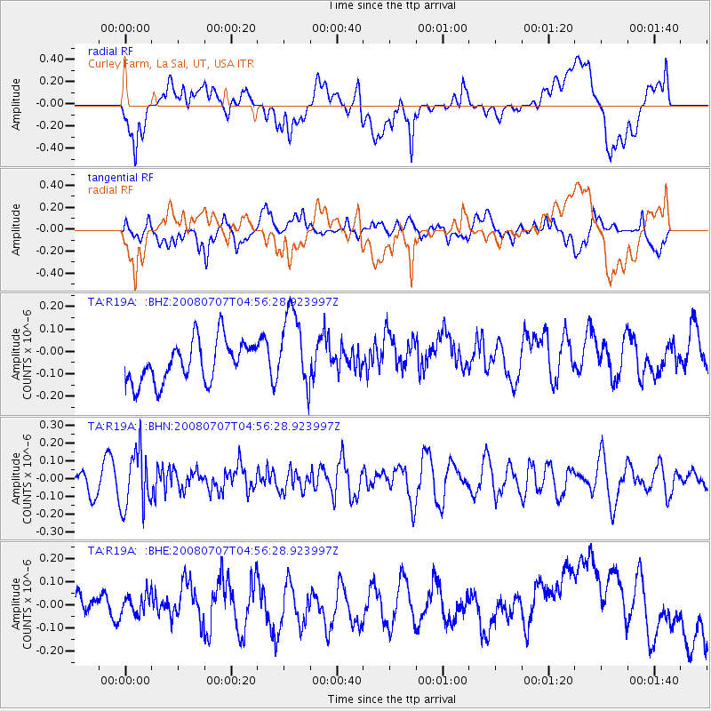
R19A Curley Farm, La Sal, UT, USA - Earthquake Result Viewer
*The percent match for this event was below the threshold and hence no stack was calculated.
| Earthquake location: |
Tonga Islands |
| Earthquake latitude/longitude: |
-16.4/-174.0 |
| Earthquake time(UTC): |
2008/07/07 (189) 04:44:55 GMT |
| Earthquake Depth: |
116 km |
| Earthquake Magnitude: |
5.5 MW, 5.0 MB, 5.5 MW |
| Earthquake Catalog/Contributor: |
WHDF/NEIC |
|
| Network: |
TA USArray Transportable Network (new EarthScope stations) |
| Station: |
R19A Curley Farm, La Sal, UT, USA |
| Lat/Lon: |
38.29 N/109.26 W |
| Elevation: |
2035 m |
|
| Distance: |
81.5 deg |
| Az: |
46.044 deg |
| Baz: |
241.397 deg |
| Ray Param: |
$rayparam |
*The percent match for this event was below the threshold and hence was not used in the summary stack. |
|
| Radial Match: |
22.1417 % |
| Radial Bump: |
400 |
| Transverse Match: |
40.87917 % |
| Transverse Bump: |
400 |
| SOD ConfigId: |
2504 |
| Insert Time: |
2010-03-06 09:47:35.297 +0000 |
| GWidth: |
2.5 |
| Max Bumps: |
400 |
| Tol: |
0.001 |
|
Signal To Noise
| Channel | StoN | STA | LTA |
| TA:R19A: :BHN:20080707T04:56:28.923997Z | 2.5162125 | 1.6387766E-7 | 6.51287E-8 |
| TA:R19A: :BHE:20080707T04:56:28.923997Z | 0.87660146 | 6.465213E-8 | 7.375316E-8 |
| TA:R19A: :BHZ:20080707T04:56:28.923997Z | 1.903545 | 1.7626509E-7 | 9.259833E-8 |
| Arrivals |
| Ps | |
| PpPs | |
| PsPs/PpSs | |


