You are here: Home > Network List > TA - USArray Transportable Network (new EarthScope stations) Stations List
> Station J26L Joseph Creek, AK, USA > Earthquake Result Viewer
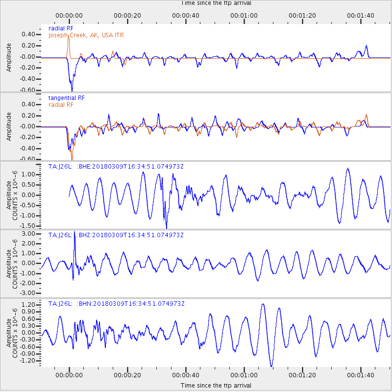
J26L Joseph Creek, AK, USA - Earthquake Result Viewer
*The percent match for this event was below the threshold and hence no stack was calculated.
| Earthquake location: |
Fiji Islands Region |
| Earthquake latitude/longitude: |
-21.1/-178.5 |
| Earthquake time(UTC): |
2018/03/09 (068) 16:23:22 GMT |
| Earthquake Depth: |
539 km |
| Earthquake Magnitude: |
5.7 Mww |
| Earthquake Catalog/Contributor: |
NEIC PDE/us |
|
| Network: |
TA USArray Transportable Network (new EarthScope stations) |
| Station: |
J26L Joseph Creek, AK, USA |
| Lat/Lon: |
64.50 N/143.56 W |
| Elevation: |
1144 m |
|
| Distance: |
89.5 deg |
| Az: |
14.37 deg |
| Baz: |
212.372 deg |
| Ray Param: |
$rayparam |
*The percent match for this event was below the threshold and hence was not used in the summary stack. |
|
| Radial Match: |
69.197845 % |
| Radial Bump: |
400 |
| Transverse Match: |
53.711456 % |
| Transverse Bump: |
400 |
| SOD ConfigId: |
13570011 |
| Insert Time: |
2019-04-29 23:11:24.551 +0000 |
| GWidth: |
2.5 |
| Max Bumps: |
400 |
| Tol: |
0.001 |
|
Signal To Noise
| Channel | StoN | STA | LTA |
| TA:J26L: :BHZ:20180309T16:34:51.074973Z | 2.704074 | 9.063819E-7 | 3.3519123E-7 |
| TA:J26L: :BHN:20180309T16:34:51.074973Z | 0.98333824 | 3.3346728E-7 | 3.3911755E-7 |
| TA:J26L: :BHE:20180309T16:34:51.074973Z | 1.576567 | 7.8375797E-7 | 4.9712946E-7 |
| Arrivals |
| Ps | |
| PpPs | |
| PsPs/PpSs | |


