You are here: Home > Network List > TA - USArray Transportable Network (new EarthScope stations) Stations List
> Station R19A Curley Farm, La Sal, UT, USA > Earthquake Result Viewer
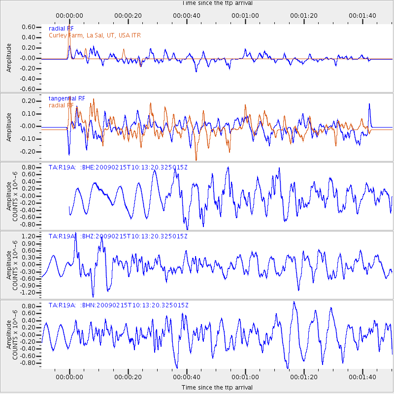
R19A Curley Farm, La Sal, UT, USA - Earthquake Result Viewer
*The percent match for this event was below the threshold and hence no stack was calculated.
| Earthquake location: |
Near Coast Of Northern Peru |
| Earthquake latitude/longitude: |
-5.9/-80.9 |
| Earthquake time(UTC): |
2009/02/15 (046) 10:04:49 GMT |
| Earthquake Depth: |
21 km |
| Earthquake Magnitude: |
5.8 MB, 5.7 MS, 6.1 MW, 6.1 MW |
| Earthquake Catalog/Contributor: |
WHDF/NEIC |
|
| Network: |
TA USArray Transportable Network (new EarthScope stations) |
| Station: |
R19A Curley Farm, La Sal, UT, USA |
| Lat/Lon: |
38.29 N/109.26 W |
| Elevation: |
2035 m |
|
| Distance: |
51.2 deg |
| Az: |
331.34 deg |
| Baz: |
142.673 deg |
| Ray Param: |
$rayparam |
*The percent match for this event was below the threshold and hence was not used in the summary stack. |
|
| Radial Match: |
59.44985 % |
| Radial Bump: |
400 |
| Transverse Match: |
33.29164 % |
| Transverse Bump: |
400 |
| SOD ConfigId: |
2658 |
| Insert Time: |
2010-03-06 09:48:00.712 +0000 |
| GWidth: |
2.5 |
| Max Bumps: |
400 |
| Tol: |
0.001 |
|
Signal To Noise
| Channel | StoN | STA | LTA |
| TA:R19A: :BHZ:20090215T10:13:20.325015Z | 1.6275623 | 4.947368E-7 | 3.039741E-7 |
| TA:R19A: :BHN:20090215T10:13:20.325015Z | 0.96708536 | 2.2367212E-7 | 2.3128477E-7 |
| TA:R19A: :BHE:20090215T10:13:20.325015Z | 1.1879783 | 3.3208008E-7 | 2.795338E-7 |
| Arrivals |
| Ps | |
| PpPs | |
| PsPs/PpSs | |


