You are here: Home > Network List > G - GEOSCOPE Stations List
> Station TAOE Taiohae, Marquises islands > Earthquake Result Viewer
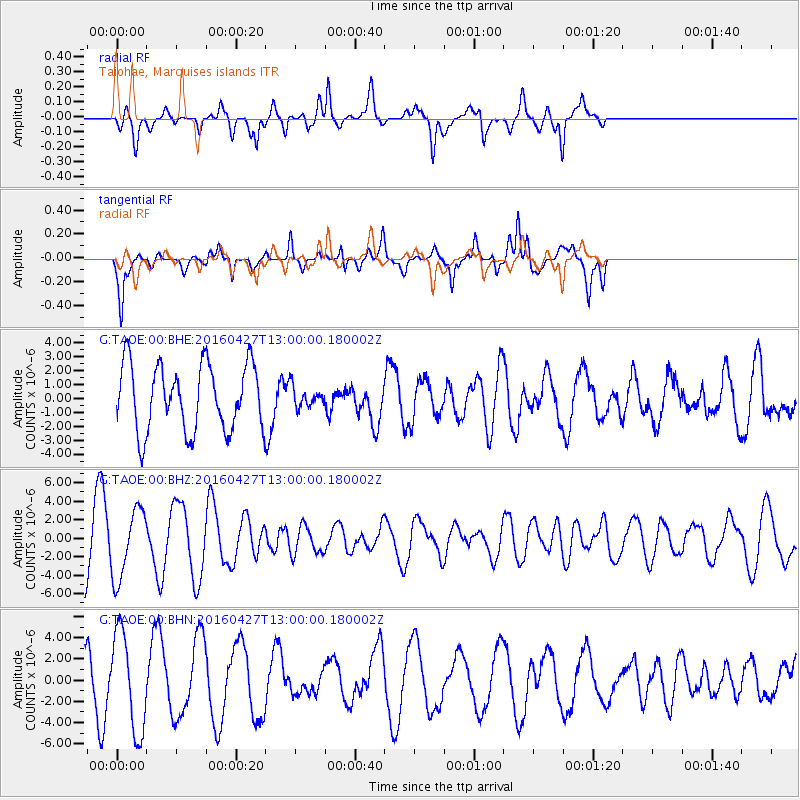
TAOE Taiohae, Marquises islands - Earthquake Result Viewer
*The percent match for this event was below the threshold and hence no stack was calculated.
| Earthquake location: |
Near Coast Of Chiapas, Mexico |
| Earthquake latitude/longitude: |
14.6/-93.0 |
| Earthquake time(UTC): |
2016/04/27 (118) 12:51:22 GMT |
| Earthquake Depth: |
35 km |
| Earthquake Magnitude: |
5.8 MB |
| Earthquake Catalog/Contributor: |
NEIC PDE/NEIC COMCAT |
|
| Network: |
G GEOSCOPE |
| Station: |
TAOE Taiohae, Marquises islands |
| Lat/Lon: |
8.85 S/140.15 W |
| Elevation: |
800 m |
|
| Distance: |
52.3 deg |
| Az: |
246.445 deg |
| Baz: |
63.913 deg |
| Ray Param: |
$rayparam |
*The percent match for this event was below the threshold and hence was not used in the summary stack. |
|
| Radial Match: |
43.081573 % |
| Radial Bump: |
400 |
| Transverse Match: |
75.63868 % |
| Transverse Bump: |
400 |
| SOD ConfigId: |
1475611 |
| Insert Time: |
2016-05-11 12:52:20.312 +0000 |
| GWidth: |
2.5 |
| Max Bumps: |
400 |
| Tol: |
0.001 |
|
Signal To Noise
| Channel | StoN | STA | LTA |
| G:TAOE:00:BHZ:20160427T13:00:00.180002Z | 1.2247822 | 3.7185982E-6 | 3.03613E-6 |
| G:TAOE:00:BHN:20160427T13:00:00.180002Z | 2.403419 | 4.665694E-6 | 1.9412737E-6 |
| G:TAOE:00:BHE:20160427T13:00:00.180002Z | 0.30238912 | 7.1612624E-7 | 2.3682276E-6 |
| Arrivals |
| Ps | |
| PpPs | |
| PsPs/PpSs | |


