You are here: Home > Network List > TA - USArray Transportable Network (new EarthScope stations) Stations List
> Station A16A West Butte Ranch, Sweetgrass, MT, USA > Earthquake Result Viewer
A16A West Butte Ranch, Sweetgrass, MT, USA - Earthquake Result Viewer
| Earthquake location: |
Tonga Islands |
| Earthquake latitude/longitude: |
-21.9/-173.8 |
| Earthquake time(UTC): |
2008/10/19 (293) 05:10:33 GMT |
| Earthquake Depth: |
29 km |
| Earthquake Magnitude: |
6.8 MB, 7.0 MS, 6.9 MW, 6.9 MW |
| Earthquake Catalog/Contributor: |
WHDF/NEIC |
|
| Network: |
TA USArray Transportable Network (new EarthScope stations) |
| Station: |
A16A West Butte Ranch, Sweetgrass, MT, USA |
| Lat/Lon: |
48.95 N/111.60 W |
| Elevation: |
1394 m |
|
| Distance: |
89.6 deg |
| Az: |
35.682 deg |
| Baz: |
235.276 deg |
| Ray Param: |
0.041730024 |
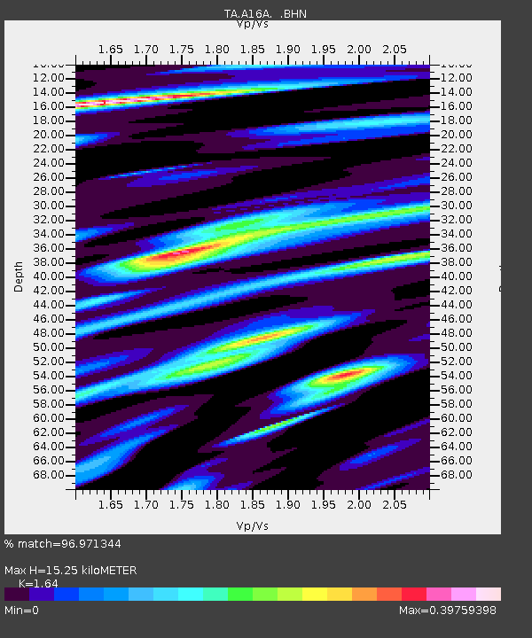
| Estimated Moho Depth: |
15.25 km |
| Estimated Crust Vp/Vs: |
1.64 |
| Assumed Crust Vp: |
6.242 km/s |
| Estimated Crust Vs: |
3.806 km/s |
| Estimated Crust Poisson's Ratio: |
0.20 |
|
| Radial Match: |
96.971344 % |
| Radial Bump: |
299 |
| Transverse Match: |
83.92138 % |
| Transverse Bump: |
400 |
| SOD ConfigId: |
2658 |
| Insert Time: |
2010-03-06 09:48:27.981 +0000 |
| GWidth: |
2.5 |
| Max Bumps: |
400 |
| Tol: |
0.001 |
|
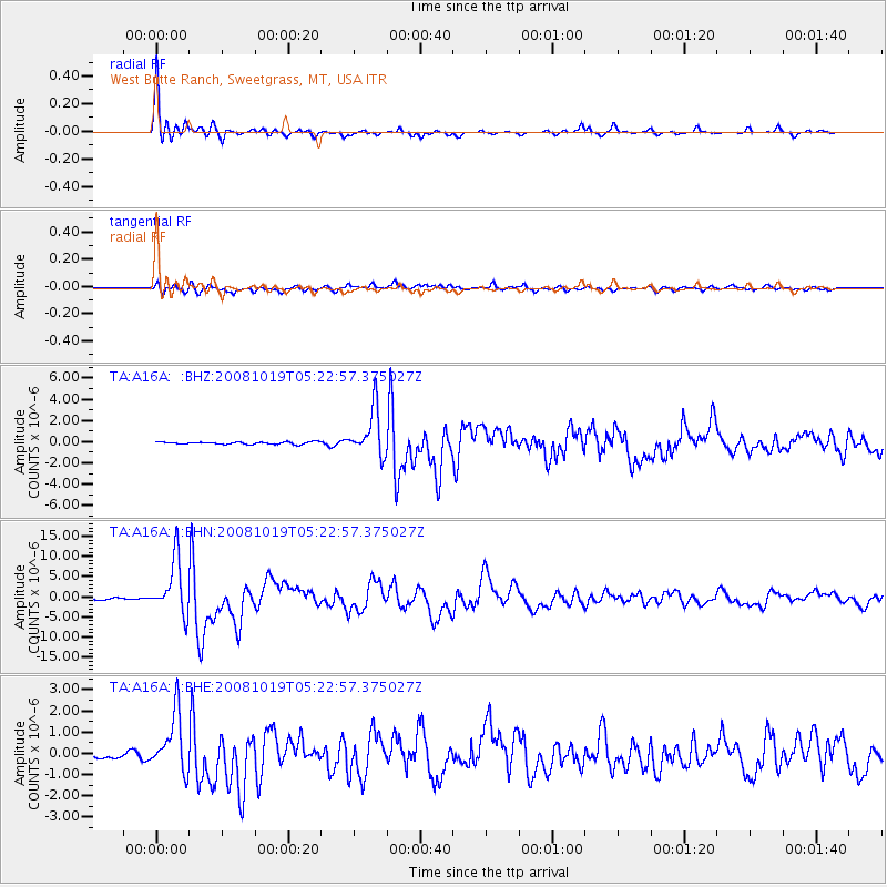
Signal To Noise
| Channel | StoN | STA | LTA |
| TA:A16A: :BHN:20081019T05:22:57.375027Z | 38.75994 | 6.744831E-6 | 1.7401551E-7 |
| TA:A16A: :BHE:20081019T05:22:57.375027Z | 6.859851 | 1.3535134E-6 | 1.9730946E-7 |
| TA:A16A: :BHZ:20081019T05:22:57.375027Z | 20.984083 | 2.182452E-6 | 1.0400511E-7 |
| Arrivals |
| Ps | 1.6 SECOND |
| PpPs | 6.3 SECOND |
| PsPs/PpSs | 7.9 SECOND |


