You are here: Home > Network List > IU - Global Seismograph Network (GSN - IRIS/USGS) Stations List
> Station RSSD Black Hills, South Dakota, USA > Earthquake Result Viewer
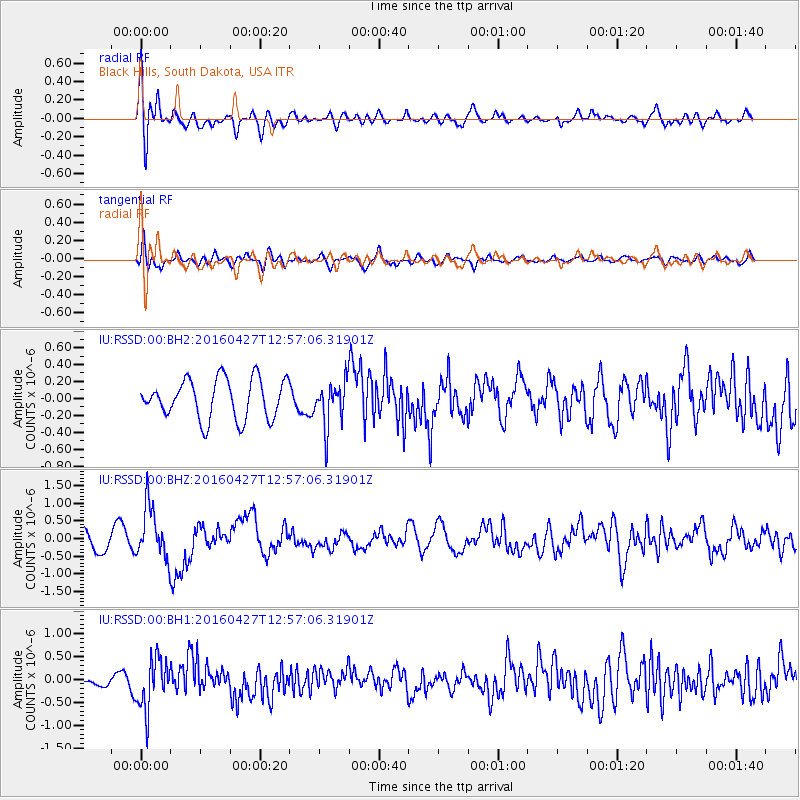
RSSD Black Hills, South Dakota, USA - Earthquake Result Viewer
*The percent match for this event was below the threshold and hence no stack was calculated.
| Earthquake location: |
Near Coast Of Chiapas, Mexico |
| Earthquake latitude/longitude: |
14.6/-93.0 |
| Earthquake time(UTC): |
2016/04/27 (118) 12:51:22 GMT |
| Earthquake Depth: |
35 km |
| Earthquake Magnitude: |
5.8 MB |
| Earthquake Catalog/Contributor: |
NEIC PDE/NEIC COMCAT |
|
| Network: |
IU Global Seismograph Network (GSN - IRIS/USGS) |
| Station: |
RSSD Black Hills, South Dakota, USA |
| Lat/Lon: |
44.12 N/104.04 W |
| Elevation: |
2090 m |
|
| Distance: |
30.9 deg |
| Az: |
344.394 deg |
| Baz: |
158.797 deg |
| Ray Param: |
$rayparam |
*The percent match for this event was below the threshold and hence was not used in the summary stack. |
|
| Radial Match: |
60.204113 % |
| Radial Bump: |
400 |
| Transverse Match: |
63.3945 % |
| Transverse Bump: |
400 |
| SOD ConfigId: |
1475611 |
| Insert Time: |
2016-05-11 12:53:36.711 +0000 |
| GWidth: |
2.5 |
| Max Bumps: |
400 |
| Tol: |
0.001 |
|
Signal To Noise
| Channel | StoN | STA | LTA |
| IU:RSSD:00:BHZ:20160427T12:57:06.31901Z | 3.2123318 | 7.3474524E-7 | 2.2872645E-7 |
| IU:RSSD:00:BH1:20160427T12:57:06.31901Z | 3.6775947 | 5.515225E-7 | 1.4996826E-7 |
| IU:RSSD:00:BH2:20160427T12:57:06.31901Z | 1.1311767 | 2.636082E-7 | 2.3303892E-7 |
| Arrivals |
| Ps | |
| PpPs | |
| PsPs/PpSs | |


