You are here: Home > Network List > TA - USArray Transportable Network (new EarthScope stations) Stations List
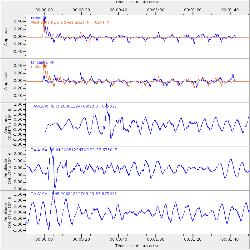
> Station A16A West Butte Ranch, Sweetgrass, MT, USA > Earthquake Result Viewer
A16A West Butte Ranch, Sweetgrass, MT, USA - Earthquake Result Viewer
| Earthquake location: |
Tonga Islands Region |
| Earthquake latitude/longitude: |
-17.3/-171.9 |
| Earthquake time(UTC): |
2008/12/24 (359) 09:11:34 GMT |
| Earthquake Depth: |
9.0 km |
| Earthquake Magnitude: |
5.9 MB, 5.6 MS, 6.0 MW, 6.0 MW |
| Earthquake Catalog/Contributor: |
WHDF/NEIC |
|
| Network: |
TA USArray Transportable Network (new EarthScope stations) |
| Station: |
A16A West Butte Ranch, Sweetgrass, MT, USA |
| Lat/Lon: |
48.95 N/111.60 W |
| Elevation: |
1394 m |
|
| Distance: |
84.8 deg |
| Az: |
35.102 deg |
| Baz: |
236.443 deg |
| Ray Param: |
0.04519124 |
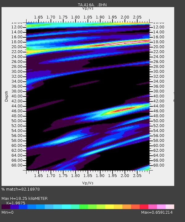
| Estimated Moho Depth: |
18.25 km |
| Estimated Crust Vp/Vs: |
2.00 |
| Assumed Crust Vp: |
6.242 km/s |
| Estimated Crust Vs: |
3.125 km/s |
| Estimated Crust Poisson's Ratio: |
0.33 |
|
| Radial Match: |
82.16978 % |
| Radial Bump: |
386 |
| Transverse Match: |
55.582066 % |
| Transverse Bump: |
259 |
| SOD ConfigId: |
2658 |
| Insert Time: |
2010-03-06 09:50:03.481 +0000 |
| GWidth: |
2.5 |
| Max Bumps: |
400 |
| Tol: |
0.001 |
|
Signal To Noise
| Channel | StoN | STA | LTA |
| TA:A16A: :BHN:20081224T09:23:37.67501Z | 3.1452174 | 1.4232081E-6 | 4.5249914E-7 |
| TA:A16A: :BHE:20081224T09:23:37.67501Z | 1.8847891 | 8.6648924E-7 | 4.597274E-7 |
| TA:A16A: :BHZ:20081224T09:23:37.67501Z | 2.4172707 | 9.356624E-7 | 3.8707392E-7 |
| Arrivals |
| Ps | 3.0 SECOND |
| PpPs | 8.6 SECOND |
| PsPs/PpSs | 12 SECOND |


