You are here: Home > Network List > TJ - Tajikistan National Seismic Network Stations List
> Station GARM Garm, Tajikistan > Earthquake Result Viewer
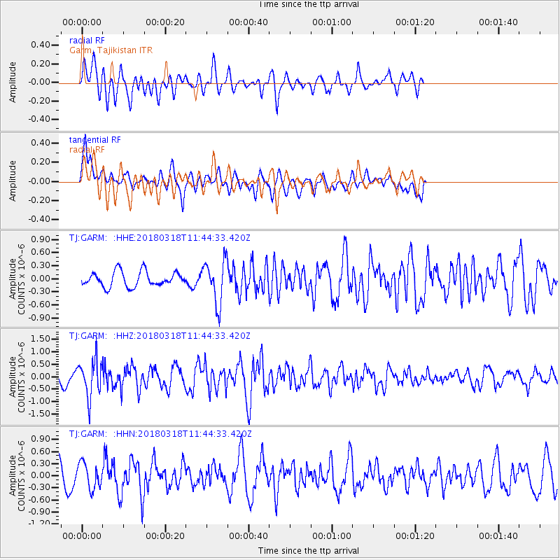
GARM Garm, Tajikistan - Earthquake Result Viewer
*The percent match for this event was below the threshold and hence no stack was calculated.
| Earthquake location: |
Minahassa Peninsula, Sulawesi |
| Earthquake latitude/longitude: |
0.5/121.5 |
| Earthquake time(UTC): |
2018/03/18 (077) 11:35:05 GMT |
| Earthquake Depth: |
107 km |
| Earthquake Magnitude: |
5.3 Mww |
| Earthquake Catalog/Contributor: |
NEIC PDE/us |
|
| Network: |
TJ Tajikistan National Seismic Network |
| Station: |
GARM Garm, Tajikistan |
| Lat/Lon: |
39.00 N/70.32 E |
| Elevation: |
1305 m |
|
| Distance: |
60.4 deg |
| Az: |
315.729 deg |
| Baz: |
116.387 deg |
| Ray Param: |
$rayparam |
*The percent match for this event was below the threshold and hence was not used in the summary stack. |
|
| Radial Match: |
72.99424 % |
| Radial Bump: |
400 |
| Transverse Match: |
60.322002 % |
| Transverse Bump: |
400 |
| SOD ConfigId: |
13570011 |
| Insert Time: |
2019-04-29 23:31:17.898 +0000 |
| GWidth: |
2.5 |
| Max Bumps: |
400 |
| Tol: |
0.001 |
|
Signal To Noise
| Channel | StoN | STA | LTA |
| TJ:GARM: :HHZ:20180318T11:44:33.420Z | 3.1612914 | 7.3850504E-7 | 2.3360866E-7 |
| TJ:GARM: :HHN:20180318T11:44:33.420Z | 1.4949373 | 3.227927E-7 | 2.1592389E-7 |
| TJ:GARM: :HHE:20180318T11:44:33.420Z | 2.8243067 | 4.86362E-7 | 1.7220582E-7 |
| Arrivals |
| Ps | |
| PpPs | |
| PsPs/PpSs | |


